Jake Stid (@jtstid) 's Twitter Profile
Jake Stid

@jtstid

PhD student at Michigan State University studying the intersection of renewable energies and agriculture

ID: 1855702597

calendar_today11-09-2013 23:04:09

769 Tweet

317 Followers

599 Following

Science News (@sciencenews) 's Twitter Profile Photo

Guitarist Brian May from the rock band Queen wrote a new song about NASA New Horizons, and will debut it at mission control in Maryland on New Year’s Eve. May has a doctorate degree in astrophysics and is officially part of the New Horizons team. #UltimaThule #Ultimaflyby

Cassini (@cassinisaturn) 's Twitter Profile Photo

Scientists may have discovered the oldest Earth rock ever—on the Moon. A lunar sample returned by the Apollo 14 astronauts may contain a bit of Earth from about 4 billion years ago. Details: go.nasa.gov/2Se5BGl

Scientists may have discovered the oldest Earth rock ever—on the Moon. A lunar sample returned by the Apollo 14 astronauts may contain a bit of Earth from about 4 billion years ago. Details: go.nasa.gov/2Se5BGl
Massimo (@rainmaker1973) 's Twitter Profile Photo

How vaccines reduced measles deaths in each state of the U.S. [Measles in the U.S. was almost eliminated with the vaccination programme starting in 1963] bit.ly/2DnXRaE

How vaccines reduced measles deaths in each state of the U.S. [Measles in the U.S. was almost eliminated with the vaccination programme starting in 1963] bit.ly/2DnXRaE
March For Science (@marchforscience) 's Twitter Profile Photo

A cool study on agrivoltaics, the co-locating of agriculture and solar photovoltaic panels. uanews.arizona.edu/story/agrivolt…

NASA Landsat (@nasa_landsat) 's Twitter Profile Photo

#ICYMI #LandsatPublication Mapping three decades of annual irrigation across the US High Plains Aquifer using Landsat and Google Earth Engine (Nov. 2019) #Landsat sciencedirect.com/science/articl…

#ICYMI #LandsatPublication 
Mapping three decades of annual irrigation across the US High Plains Aquifer using Landsat and Google Earth Engine (Nov. 2019)
#Landsat 
sciencedirect.com/science/articl…
MSU Hydrogeology Lab (@msuhydro) 's Twitter Profile Photo

Congratulations to Ally Brady Ally Brady for successfully defending her MS Thesis, ā€œAssessing Irrigation Trends in the High Plains Aquifer Region: Irrigation Trends and Mapping Efficient Irrigation Useā€!

Congratulations to Ally Brady <a href="/ally_jane429/">Ally Brady</a> for successfully defending her MS Thesis, ā€œAssessing Irrigation Trends in the High Plains Aquifer Region: Irrigation Trends and Mapping Efficient Irrigation Useā€!
Robin Hawkes (@robhawkes) 's Twitter Profile Photo

Introducing āš”ļøGB Renewables Mapāš”ļø – my latest (personal) energy experiment Play with a map showing live generation for major wind farms in Great Britain, showing what each farm is generating and where that generation is physically located. More soon! šŸ‘€ renewables-map.robinhawkes.com

MSU Hydrogeology Lab (@msuhydro) 's Twitter Profile Photo

Irrigation in the eastern half of the US is expanding rapidly, and will likely continue to do so for decades to come. natsci.msu.edu/news/2023-08-i…

Irrigation in the eastern half of the US is expanding rapidly, and will likely continue to do so for decades to come. natsci.msu.edu/news/2023-08-i…
Harvest (@harvestprogram) 's Twitter Profile Photo

Check out maize and soybean planting dates have changed across the US Midwest over the past 20 years! NASA Harvest's Jillian Deines and her team have published field-scale planting date maps for the region going back to 2000. šŸ”—nasaharvest.org/index.php/news…

Check out maize and soybean planting dates have changed across the US Midwest over the past 20 years!

NASA Harvest's <a href="/JillDeines/">Jillian Deines</a> and her team have published field-scale planting date maps for the region going back to 2000. 
šŸ”—nasaharvest.org/index.php/news…
USGS Coastal Change (@usgscoastchange) 's Twitter Profile Photo

#USGS scientists have created the first CONUS-wide #coastalwetlands collection. The collection contains datasets necessary to understand the status, geographical setting, and benefits #wetlands provide. Learn more! ow.ly/Q9Ne50Q2Ioe

#USGS scientists have created the first CONUS-wide #coastalwetlands collection.

The collection contains datasets necessary to understand the status, geographical setting, and benefits #wetlands provide.

Learn more! ow.ly/Q9Ne50Q2Ioe
Landon Marston (@landonmarston) 's Twitter Profile Photo

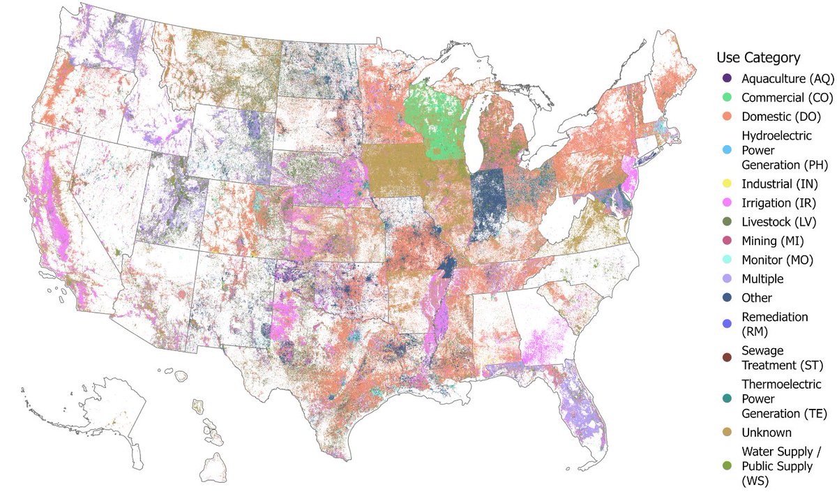
We introduce the United States Groundwater Well Database (USGWD), which contains 14.2+ million use and monitoring wells across the US. 1/9 Paper: rdcu.be/dDGDY Data: hydroshare.org/resource/8b028…

We introduce the United States Groundwater Well Database (USGWD), which contains 14.2+ million use and monitoring wells across the US. 1/9
Paper: rdcu.be/dDGDY
Data: hydroshare.org/resource/8b028…