Geography of Kenya
@kenyangeography
Exploring Kenya's geography ▶
A showcase of the country's geographical features and how they shape lives ▶
YouTube ⬇️ youtube.com/@kenyangeograp…
ID: 1203284817212825609
07-12-2019 12:08:34
4,4K Tweet
36,36K Followers
213 Following
 on Twitter photo Isiolo town is located on a plain at the edge of the Mt. Kenya highlands, in the center of the country.
Despite being just 50km away from the mountain, Isiolo town lies at a relatively low altitude of 1100m. The change in elevation is seen in the steep descent from Timau.")
 on Twitter photo The Red Hill link road has numerous river valleys where tributaries of Mathare river flow under the highway.
Mathare river flows parallel to Lower Kabete road and under the Red Hill link road at this junction 📸.
Nairobi's road network is shaped by the city's numerous rivers.")
 's Twitter Profile Photo")
Hidden gem deep in the heart of Nairobi? 😅😅😅 Exactly why we need the cleaning of Nairobi River honestly Geography of Kenya
 on Twitter photo The southern section of the 110km long Nyandarua (Aberdares) mountain range overlooks the Rift valley section between Gilgil and Naivasha on the western side.
The 3999m peak is the highest in this section. This is the backdrop of the #SafariRallyKenya
📸 From Nairobi.")
 on Twitter photo Manguo is located adjacent to the Rift valley escarpment outside Limuru town. The highway descends steeply over 5km from the Rift valley viewpoint towards Limuru junction. Road redesign or speed limit enforcement to slow down drivers would offer a solution.")
Elevation variation of over 4000m captured in one photo. From an elevation of 1100m in Isiolo in the foreground to the 5199m Batian peak of Mt. Kenya. Photo depth has a total distance of 50km, as the crow flies. National Geographic
 on Twitter photo Elevation variation of over 4000m captured in one photo. From an elevation of 1100m in Isiolo in the foreground to the 5199m Batian peak of Mt. Kenya. Photo depth has a total distance of 50km, as the crow flies.
<a href=\"/NatGeo/\">National Geographic</a>")
 on Twitter photo Nyambene mountain range is located to the North East of Mt. Kenya.
The range rises to a peak of 2500m in the southern section. The fertile mountain with volcanic soil and rain allows growing of cash crops like tea and miraa. Most of Kenyan miraa is grown in Nyambene range.")
 on Twitter photo Natural features are used to delineate boundaries between territories. The Kenya-Ethiopia border is marked by an escarpment that extends for over 100km between Sololo and Gurar. Kenya is on the lower plains while the rise of the Ethiopian highlands begins at this point.")
 on Twitter photo World Environment Day on 5th June encourages awareness for environmental protection.
Join change makers & funders in an interactive session on creation of strategies to improve resource efficiency, reduce waste and boost economic growth
Registration link shorturl.at/US7T4")
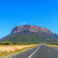
 on Twitter photo Once upon a time, Mt. Ololokwe was ancient rock buried under the Samburu plains. Millions of years of erosion exposed this rocky outcrop to form one of Kenya's most outstanding inselbergs.
Today, Mt. Ololokwe stands 1000m above the surrounding plains, still resisting erosion.")
 on Twitter photo Elevation increases gradually west of Nairobi towards the highlands adjacent to the rift valley escarpment.
In this image, Lavington in the foreground has an elevation of 1800m while Limuru in the background rises to 2300m.
The rivers of Nairobi flow from these highlands.")
 on Twitter photo Subuiga area (Timau) at the foothills of Mt. Kenya is an important region for cross-country connectivity.
1. Electricity imported from Ethiopia passes through this corridor;
2. Elephants from the North ascend Mt. Kenya via an underpass;
3. A2 highway ascends to central Kenya.")
 on Twitter photo Muslims around the world are performing the Hajj pilgrimage in Makkah.
Like much of the western edge of the Arabian peninsula, Makkah is located adjacent to the hills that form part of the rift valley escarpment.
This screen shot gives a glimpse of Makkah hills at sunset.")