Laxmi Thapa (@laxmi15thapa) 's Twitter Profile
Laxmi Thapa

@laxmi15thapa

President, ISPRS SC
MSc. Geospatial Technologies(Erasmus)
Learner of #MachineLearning #Geoinformatics #RemoteSensing
Tweets are solely personal.

ID: 2988613100

calendar_today18-01-2015 14:01:11

124 Tweet

224 Followers

893 Following

Ladies of Landsat (@ladiesoflandsat) 's Twitter Profile Photo

.@KEJoyce2, Karen Anderson & Renee Bartolo (2021) make targetted recommendations to use #unoccupied (not #unmanned) when referring to #UAS #UAVs to ensure an inclusive @DamesofDrones community in their She Maps special issue intro. #LoLManuscriptMonday bit.ly/SheMaps_2021

.@KEJoyce2, <a href="/KAnderson_RS/">Karen Anderson</a> &amp; <a href="/ReneeBartolo/">Renee Bartolo</a> (2021) make targetted recommendations to use #unoccupied (not #unmanned) when referring to #UAS #UAVs to ensure an inclusive @DamesofDrones community in their <a href="/shemapsau/">She Maps</a> special issue intro. #LoLManuscriptMonday bit.ly/SheMaps_2021

Women+ in Geospatial (@geospatialwomen) 's Twitter Profile Photo

Are you going to FOSS4G 2024 | https://fosstodon.org/@foss4g ? Women+ in Geospatial and Geochicas welcomes you to meet other women+ & allies attending #FOSS4G2022 who are interested in closing the gender gap and working towards diversity in our communities. Register here: mobilizon.it/events/dc5b147…

Radiant Earth (@ourradiantearth) 's Twitter Profile Photo

Radiant Earth is excited to announce the release of LandCoverNet, the first global multi-satellite training dataset for land cover classification. #LandCoverNet will enable the creation of high-resolution & up-to-date maps for natural resource management bit.ly/3nVxdhE

Radiant Earth is excited to announce the release of LandCoverNet, the first global multi-satellite training dataset for land cover classification. #LandCoverNet will enable the creation of high-resolution &amp; up-to-date maps for natural resource management bit.ly/3nVxdhE
Laxmi Thapa (@laxmi15thapa) 's Twitter Profile Photo

Here's an alert to the free virtual summer school on Resilient Cities happening on July 25-29! Only 5 days left for the registration! #isprs #isprssc #summerschool #bucea

Sisters of SAR (@sistersofsar) 's Twitter Profile Photo

⭐️#SAR_STAR #SoSfact! ⁉️DYK Sisters of SAR has a website: sistersofsar.wixsite.com/sistersofsar, a LinkedIn account: linkedin.com/in/sisters-of-… & a #Facebook account: facebook.com/sis.ofsar/. We are working to get these two new accounts up & running to reach more fantastic #SAR folks! #EOChat

AMRIT THAPA (@amrit2044) 's Twitter Profile Photo

It's such a coincidence! This afternoon we were discussing hydroSAR and the Koshi River in Nepal is currently following its historical path after 34 years. Note the diagonal water channel that appeared on August 1. #SAR #hydroSAR #flood #Sentinel1 #FreelyAvailableData

Open Mapping Hub Asia-Pacific (@openmapping_ap) 's Twitter Profile Photo

We are offering up to 10 sponsorships to student clubs/ organizations from universities in the #AsiaPacific region for one year looking to implement #OpenStreetMap and other #openmapping activities. For more information on the sponsorship and to apply - hotosm.org/updates/omhap-…

We are offering up to 10 sponsorships to student clubs/ organizations from universities in the #AsiaPacific region for one year looking to implement #OpenStreetMap and other #openmapping activities.

For more information on the sponsorship and to apply - hotosm.org/updates/omhap-…
Women+ in Geospatial (@geospatialwomen) 's Twitter Profile Photo

Our #Mentorship Cohort 4 application is open now and CLOSING in 17 days! Apply by September 15th for your chance to build mentorship relationships with #WomenInGeospatial! womeningeospatial.org/mentorship-pro… Check out our legacy gallery from last year! shorturl.at/BEJZ2

Our #Mentorship Cohort 4 application is open now and CLOSING in 17 days! Apply by September 15th for your chance to build mentorship relationships with #WomenInGeospatial! 
womeningeospatial.org/mentorship-pro… 
 
Check out our legacy gallery from last year! shorturl.at/BEJZ2
IEEE Geoscience and Remote Sensing Society (@ieee_grss) 's Twitter Profile Photo

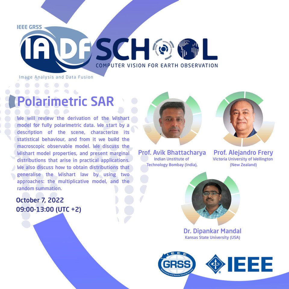
📣 IEEE GRSS First IADF School on #ComputerVision for #EarthObservation GRSS IADF 📺 Online School ℹ️ The selected participants will receive a certificate 🗓️ Monday, October 3 – Friday, October 7, 2022 ⚠️ Deadline : September 23, 2022 ✍️ Apply iadf-school.org

📣 IEEE GRSS First IADF School on 
#ComputerVision for #EarthObservation <a href="/GrssIadf/">GRSS IADF</a>
📺 Online School 
ℹ️ The selected participants will receive a certificate 
🗓️ Monday, October 3 – Friday, October 7, 2022
⚠️ Deadline : September 23, 2022 
✍️ Apply iadf-school.org
ISPRS SC (@isprs_sc) 's Twitter Profile Photo

📢 October 2022 GeoMixer This is a special event for the attendees of the 43rd Asian Conference on Remote Sensing (ACRS 2022). Participants who are not participating in the conference are also welcomed in this GeoMixer! Sign up here: forms.gle/fBwkD9VS6cbJb4…

📢 October 2022 GeoMixer

This is a special event for the attendees of the 43rd Asian Conference on Remote Sensing (ACRS 2022). Participants who are not participating in the conference are also welcomed in this GeoMixer!

Sign up here: forms.gle/fBwkD9VS6cbJb4…
ISPRS SC (@isprs_sc) 's Twitter Profile Photo

📢 5 days till the webinar! ‼️ Registration is still open! 🔗To those who have already registered, we will send the zoom link soon!

AMRIT THAPA (@amrit2044) 's Twitter Profile Photo

Although HKH is often called a data scare region, we have already collected valuable data. Here is a link where you can download the data. #HKH #data #Himalaya #ICIMOD #RDS

EO OPEN SCIENCE (@eo_open_science) 's Twitter Profile Photo

The European Space Agency European Space Agency proudly announces the release of the WorldCover2021 map based on Sentinel-2 & Sentinel-1 constellations with 11 classes, 10m resolution, 77% accuracy independently validated Visit worldcover2021.esa.int ESA Earth Observation #EuropeanSpaceAgency #WorldCover2021

The European Space Agency <a href="/esa/">European Space Agency</a> proudly announces the release of the WorldCover2021 map based on Sentinel-2 &amp; Sentinel-1 constellations with 11 classes, 10m resolution, 77% accuracy independently validated
Visit worldcover2021.esa.int <a href="/ESA_EO/">ESA Earth Observation</a> 
#EuropeanSpaceAgency #WorldCover2021
AMRIT THAPA (@amrit2044) 's Twitter Profile Photo

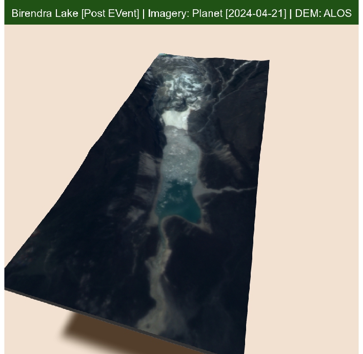
Birendra Lake Update: It appears to be an episode of avalanches. The one on the 20th seemed smaller, but satellite images from the 21st reveal a larger one. Possibly a detachment of glacier tongue/terminus. #BirendraLake #GLOF #Nepal #Himalaya

Birendra Lake Update: It appears to be an episode of avalanches. The one on the 20th seemed smaller, but satellite images from the 21st reveal a larger one. Possibly a detachment of glacier tongue/terminus.

#BirendraLake #GLOF #Nepal #Himalaya