Lawrence #Geospatial🌍 (@lawrence_kim_) 's Twitter Profile
Lawrence #Geospatial🌍

@lawrence_kim_

#Geospatial & Remote Sensing | G.I.S developer | Vue JS | Data Science | Python | R | #ArcGIS | #earthengine | AI/ML | #gischat

ID: 1249846131040845830

linkhttps://lawrence-portfolio-website.netlify.app/ calendar_today13-04-2020 23:45:26

6,6K Tweet

2,2K Followers

2,2K Following

Humanitarian Research Lab (HRL) at YSPH (@hrl_yalesph) 's Twitter Profile Photo

🚨HUMAN SECURITY EMERGENCY🚨 El-Fasher has fallen to RSF. HRL finds evidence of mass killings including door-to-door clearance operations and objects consistent with reported bodies on berm entrapping El-Fasher. #KeepEyesOnSudan 🛰️Airbus Space @Maxar medicine.yale.edu/lab/khoshnood/…
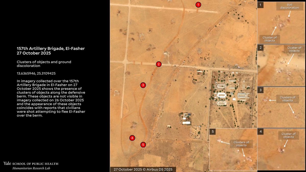
🚨HUMAN SECURITY EMERGENCY🚨 
El-Fasher has fallen to RSF. HRL finds evidence of mass killings including door-to-door clearance operations and objects consistent with reported bodies on berm entrapping El-Fasher.
#KeepEyesOnSudan

🛰️<a href="/AirbusSpace/">Airbus Space</a> @Maxar
medicine.yale.edu/lab/khoshnood/…

Raman Osipau (@osipauroma54190) 's Twitter Profile Photo

Kenya is one of the largest global suppliers of fresh cut roses. In accordance with the latest GTAIC Market intelligence platfrom report, Kenya is n4 largest global exporter of fresh roses, after Ecuador, Colombia and Netherlands (if exports measured in $). If measured in tons,

Kenya is one of the largest global suppliers of fresh cut roses. 
In accordance with the latest GTAIC Market intelligence platfrom report, Kenya is n4 largest global exporter of fresh roses, after Ecuador, Colombia and Netherlands (if exports measured in $). If measured in tons,
Remote Sensing MDPI (@remotesens_mdpi) 's Twitter Profile Photo

🏙️🏢 Semantic #Segmentation-Driven Integration of #PointClouds from Mobile Scanning Platforms in #Urban Environments ✍️ Joanna Koszyk et al. 🔗 brnw.ch/21wX1DF

🏙️🏢 Semantic #Segmentation-Driven Integration of #PointClouds from Mobile Scanning Platforms in #Urban Environments

✍️ Joanna Koszyk et al.
🔗 brnw.ch/21wX1DF
HMC (@47k254) 's Twitter Profile Photo

A Chinese cyber gang spent over a year hiding inside ArcGIS — the trusted mapping software — without anyone noticing. 😳 No fancy malware, just a sneaky tweak to a legit server extension that turned into a backdoor. Even system restores brought them back like a bad ex. 💀 And

A Chinese cyber gang spent over a year hiding inside ArcGIS — the trusted mapping software — without anyone noticing. 😳

No fancy malware, just a sneaky tweak to a legit server extension that turned into a backdoor. Even system restores brought them back like a bad ex. 💀

And
UNOSAT (@unosat) 's Twitter Profile Photo

#Jamaica - Satellite-based analysis of Crawford Village (Black River District, Saint Elizabeth Parish) following TC #MELISSA25. All 1,089 buildings in AOI identified as damaged or destroyed as of 29 Oct 2025: unosat.org/products/4211 UNITAR @IFRC UN Development @OCHA United Nations Jamaica Multi-country Office

#Jamaica  - Satellite-based analysis of Crawford Village (Black River District, Saint Elizabeth Parish) following TC #MELISSA25. 
All 1,089 buildings in AOI identified as damaged or destroyed as of 29 Oct 2025: unosat.org/products/4211
<a href="/UNITAR/">UNITAR</a> @IFRC <a href="/UNDP/">UN Development</a> @OCHA <a href="/UNJamaica/">United Nations Jamaica Multi-country Office</a>
GitHub (@github) 's Twitter Profile Photo

The numbers are in. 📈 With 1.12 billion contributions on GitHub from over 180 million developers, we took a closer look at the state of software development. This year saw record growth, surging uses in AI, and significant shifts in programming languages. What other stories do

The numbers are in. 📈

With 1.12 billion contributions on GitHub from over 180 million developers, we took a closer look at the state of software development.

This year saw record growth, surging uses in AI, and significant shifts in programming languages. What other stories do
Angela Dai (@angelaqdai) 's Twitter Profile Photo

📢New in ScanNet++: High-Res 360° Panos! Chandan Yeshwanth & Yueh-Cheng Liu have added pano captures for 956 ScanNet++ scenes, fully aligned with the 3D meshes, DSLR, and iPhone data - multiple panos per scene Check it out: Docs kaldir.vc.in.tum.de/scannetpp/docu… Code github.com/scannetpp/scan…

Airbus Space (@airbusspace) 's Twitter Profile Photo

Jamaica hit hard by Hurricane Melissa 🌀🌎 On 28 October, 2025, category 5 Hurricane Melissa hit Jamaica and strongly impacted the island with maximum sustained winds of 297 km/h (185 mph). The hurricane first made landfall in southwestern Jamaica next to Black River city in

Jamaica hit hard by Hurricane Melissa 🌀🌎

On 28 October, 2025, category 5 Hurricane Melissa hit Jamaica and strongly impacted the island with maximum sustained winds of 297 km/h (185 mph). The hurricane first made landfall in southwestern Jamaica next to Black River city in
Cesium (@cesiumjs) 's Twitter Profile Photo

Will we see you at FOSS4G North America in Reston next week? Hear from Patrick Cozzi at the B2B, Luke McKinstry about CesiumJS, and Matt Schwartz about #3DTiles. Visit teammates at the Cesium table and chat with us at the hootenanny, too. Details: hubs.li/Q03QPh0K0

Will we see you at <a href="/foss4gna/">FOSS4G North America</a> in Reston next week?

Hear from <a href="/pjcozzi/">Patrick Cozzi</a> at the B2B, Luke McKinstry about CesiumJS, and Matt Schwartz about #3DTiles. Visit teammates at the Cesium table and chat with us at the hootenanny, too.

Details: hubs.li/Q03QPh0K0
Bert Temme (@berttemme) 's Twitter Profile Photo

Convert #CityGML to 3D Tiles using @3DCityDB v5 the easy way. Result demo: bertt.github.io/3dcitydb_demos… (blog follows)

Convert #CityGML to 3D Tiles using @3DCityDB v5 the easy way. Result demo: bertt.github.io/3dcitydb_demos… (blog follows)
Kyle Walker (@kyle_e_walker) 's Twitter Profile Photo

The #30DayMapChallenge starts tomorrow across social media platforms! Pay attention to this hashtag if you love maps - there will be tons of creative examples from around the world.

The #30DayMapChallenge starts tomorrow across social media platforms!

Pay attention to this hashtag if you love maps - there will be tons of creative examples from around the world.
Laurence Oakes-Ash (@loakesash) 's Twitter Profile Photo

Day 1 of the #30DayMapChallenge - Points! Check out three different interactive views of the DESNZ statistics NAEI. Click on the eye icon to filter the data by sector. See sectoral clusters and the largest emitters based on the point sizes. Interactive links in the comments.

Day 1 of the #30DayMapChallenge - Points! Check out three different interactive views of the <a href="/DESNZ_stats/">DESNZ statistics</a> NAEI. Click on the eye icon to filter the data by sector. See sectoral clusters and the largest emitters based on the point sizes.
Interactive links in the comments.
World Meteorological Organization (@wmo) 's Twitter Profile Photo

🛰️ WMO congratulates the China Meteorological Administration (中国气象局 CMA) on the successful release of the first set of images from the FY-3H meteorological satellite, marking another major milestone in advancing the global Earth observation system!

🛰️ WMO congratulates the China Meteorological Administration (<a href="/cmanewsinfocus/">中国气象局 CMA</a>) on the successful release of the first set of images from the FY-3H meteorological satellite, marking another major milestone in advancing the global Earth observation system!
Copernicus EU (@copernicuseu) 's Twitter Profile Photo

The Inland Delta of the Niger River in Mali, a Ramsar site, is a lifeline for agriculture and wildlife. Near the Sahara, wind-shaped sand dunes stay exposed during floods, creating striking parallel patterns. 🛰️ Captured by #CopernicusEU Sentinel-2. #ImageOfTheDay

The Inland Delta of the Niger River in Mali, a Ramsar site, is a lifeline for agriculture and wildlife. 

Near the Sahara, wind-shaped sand dunes stay exposed during floods, creating striking parallel patterns.

🛰️ Captured by #CopernicusEU Sentinel-2.

#ImageOfTheDay
Python Maps (@pythonmaps) 's Twitter Profile Photo

Day 2 of the #30DayMapChallenge - Lines. This map shows the rivers of Africa, coloured according to the minimum river temperature.

Day 2 of the #30DayMapChallenge - Lines. This map shows the rivers of Africa, coloured according to the minimum river temperature.