Lindsey Anderson (@lnanderson) 's Twitter Profile
Lindsey Anderson

@lnanderson

AMS Certified Meteorologist ❄️⚡️ | Mornings on @KSHB41 in KC | NC State Alum 🐺 | Boy mom 🧢 | Night owl living an early bird life 🐤

ID: 1596552528

linkhttps://instagram.com/linds_anders?igshid=YmlmYmMwdmIwbThz&utm_source=qr calendar_today15-07-2013 19:27:16

18,18K Tweet

11,11K Followers

1,1K Following

Jeff Penner (@jeffpennerkshb) 's Twitter Profile Photo

We will see calmer, but cool weather tonight. April is going to start with active weather as our next significant storm system to track arrives Tuesday. Details on the active weather are in our updated KSHB 41 News weather blog at: kshb.com/weather/kshb-4…

We will see calmer, but cool weather tonight. April is going to start with active weather as our next significant storm system to track arrives Tuesday.

Details on the active weather are in our updated <a href="/KSHB41/">KSHB 41 News</a> weather blog at:

kshb.com/weather/kshb-4…
Lindsey Anderson (@lnanderson) 's Twitter Profile Photo

Our next round of severe weather ramps up tomorrow night, after 9pm. A slight risk (level 2/5) is in place for the entire area as all hazards are possible. Large hail & strong winds are most likely, but the tornado threat is not zero, especially if storms form ahead of a front!

Our next round of severe weather ramps up tomorrow night, after 9pm. A slight risk (level 2/5) is in place for the entire area as all hazards are possible. Large hail &amp; strong winds are most likely, but the tornado threat is not zero, especially if storms form ahead of a front!
Lindsey Anderson (@lnanderson) 's Twitter Profile Photo

Prepare for a noisy & active night tonight! Severe storms are likely between 9pm - 4am with all severe hazards possible. The greatest tornado & large hail threat is highlighted in the orange area, southwest of KC. Make sure emergency alerts are on before going to bed tonight!

Prepare for a noisy &amp; active night tonight! Severe storms are likely between 9pm - 4am with all severe hazards possible. The greatest tornado &amp; large hail threat is highlighted in the orange area, southwest of KC. Make sure emergency alerts are on before going to bed tonight!
Lindsey Anderson (@lnanderson) 's Twitter Profile Photo

UPDATE: An Enhanced Risk (level 3/5) now includes the KC metro, areas up to 36-HWY & western Missouri for the increased potential of 75+ mph winds along the squall line that comes through after 12am. The tornado & hail risk still present but more likely over central/eastern KS.

UPDATE: An Enhanced Risk (level 3/5) now includes the KC metro, areas up to 36-HWY &amp; western Missouri for the increased potential of 75+ mph winds along the squall line that comes through after 12am. The tornado &amp; hail risk still present but more likely over central/eastern KS.
Lindsey Anderson (@lnanderson) 's Twitter Profile Photo

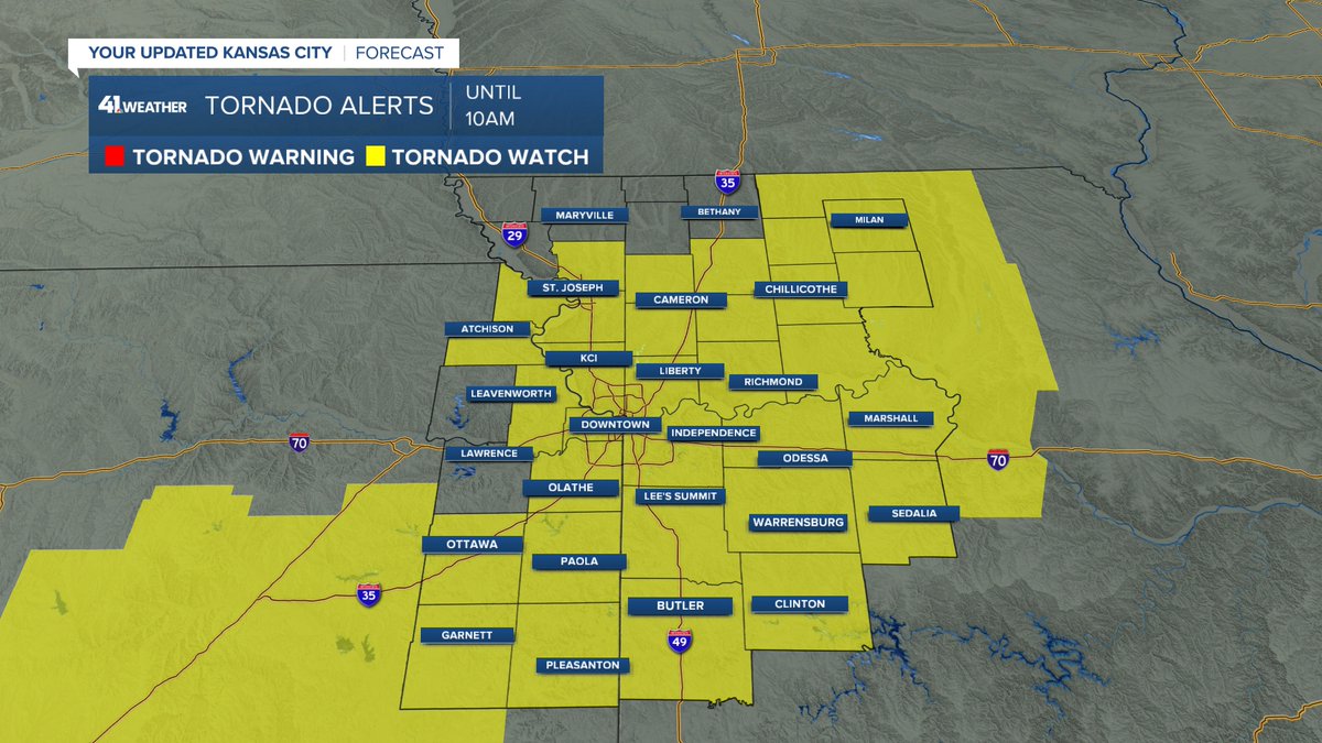
A Tornado Watch now in effect for most of our area as a line of storms approaches KC around 5-8am. Storms could also produce strong, damaging wind gusts & hail into the morning commute.

A Tornado Watch now in effect for most of our area as a line of storms approaches KC around 5-8am. Storms could also produce strong, damaging wind gusts &amp; hail into the morning commute.
Lindsey Anderson (@lnanderson) 's Twitter Profile Photo

The squall line is getting close! We now have Severe Thunderstorm Warnings that extend from Douglas, Jefferson, Leavenworth & Platte counties as this line could produce 60 mph wind gusts & quarter size hail. The warnings are in place until 3:45am.

The squall line is getting close! We now have Severe Thunderstorm Warnings that extend from Douglas, Jefferson, Leavenworth &amp; Platte counties as this line could produce 60 mph wind gusts &amp; quarter size hail. The warnings are in place until 3:45am.
Lindsey Anderson (@lnanderson) 's Twitter Profile Photo

3:45am: A Severe Thunderstorm Warning includes much of the KC Metro as the line of storms is quickly approaching. Prepare for strong wind gusts along the leading edge. This warning is in place until 4:15am.

Lindsey Anderson (@lnanderson) 's Twitter Profile Photo

3:50am RADAR: Getting ready for a very noisy next few hours over KC! Here's when you can expect the line of severe storms to enter your area.

3:50am RADAR: Getting ready for a very noisy next few hours over KC! Here's when you can expect the line of severe storms to enter your area.
Lindsey Anderson (@lnanderson) 's Twitter Profile Photo

WOAH look at this squall line! AMAZING! It's over 500 miles long with warnings along the entire line from northern Missouri to the TX/OK border.

WOAH look at this squall line! AMAZING! It's over 500 miles long with warnings along the entire line from northern Missouri to the TX/OK border.
Lindsey Anderson (@lnanderson) 's Twitter Profile Photo

5:30AM RADAR: A line of severe storms is making its way across the city this morning. A Severe Thunderstorm Warning has been issued from Jackson County, MO to Linn County, KS until 6:15am. Strong winds up to 60 mph most likely. The extremely heavy rain will impact roads too!

Lindsey Anderson (@lnanderson) 's Twitter Profile Photo

A very dangerous situation sets up out east today as the same line of storms we’re experiencing this morning moves into the Mississippi River Valley by the early evening.

FOX Weather (@foxweather) 's Twitter Profile Photo

Video from Nevada, Missouri shows the destruction after a possible tornado touched down in the community as severe thunderstorms slam across the country today. foxweather.com/weather-news/s…

Wes Peery (@wesweather) 's Twitter Profile Photo

An EF-0 moved through Bates County near Butler and Ballard this morning. The weak tornado damaged trees, power poles, and some small farm buildings. No injuries reported #mowx