Miguel Booth (@mboothp) 's Twitter Profile
Miguel Booth

@mboothp

Filmmaker and adventurer with a passion for mountains, polar regions and wildlife. Born at 330 ppm CO2🔥

ID: 353164755

linkhttp://www.go-dreamcatcher.com calendar_today11-08-2011 17:04:35

2,2K Tweet

624 Followers

710 Following
European Space Agency (@esa) 's Twitter Profile Photo

ESA and CNES are determined to reduce the footprint of rocket launches and ground operations at Centre spatial guyanais in French Guiana, and are aiming to deliver low-carbon hydrogen generated by solar-powered electrolysis of water by 2026. esa.int/Enabling_Suppo…

ESA Earth Observation (@esa_eo) 's Twitter Profile Photo

Get your coffee and snacks ready - liftoff of Metop-SG-A1, which hosts Copernicus Sentinel-5 as part of its instrument package, is set for 02:37 CEST on 13 August🚀 Keep us company and follow the launch live on esawebtv.esa.int from 02:10 CEST.

Get your coffee and snacks ready - liftoff of Metop-SG-A1, which hosts Copernicus Sentinel-5 as part of its instrument package, is set for 02:37 CEST on 13 August🚀

Keep us company and follow the launch live on esawebtv.esa.int from 02:10 CEST.
ESA Earth Observation (@esa_eo) 's Twitter Profile Photo

We have received confirmation that MetOp-SG-A1 is alive and well, after its solar array has been deployed, ensuring that the satellite could generate power🔋 We can now celebrate two new missions, EUMETSAT's MetOp-SG-A1 and Copernicus EU Sentinel-5A: esa.int/Applications/O…

European Space Agency (@esa) 's Twitter Profile Photo

Tonight, we ushered in a new era of weather and climate monitoring. Europe’s first MetOp Second Generation, MetOp-SG-A1, weather satellite – which hosts the Copernicus Sentinel-5 mission –  successfully launched aboard an Ariane 6 rocket from Europe’s Spaceport in French Guiana

Tonight, we ushered in a new era of weather and climate monitoring.

Europe’s first MetOp Second Generation, MetOp-SG-A1, weather satellite – which hosts the Copernicus Sentinel-5 mission –  successfully launched aboard an Ariane 6 rocket from Europe’s Spaceport in French Guiana
World Meteorological Organization (@wmo) 's Twitter Profile Photo

This video from USGS shows the Mendenhall Glacier, Alaska, forming a natural ice dam as meltwater triggers a glacial lake outburst flood (GLOF). This is a stark reminder: the cryosphere is changing, and with it, the risks we face. #Glaciers2025

ESA Earth Observation (@esa_eo) 's Twitter Profile Photo

Soaring temperatures and dry land have fuelled widespread wildfires in Southern Europe, with Spain and Portugal among the regions hardest hit: esa.int/Applications/O… As reported by Copernicus ECMWF, in the past 6 days emissions for Spain have reached the highest annual total
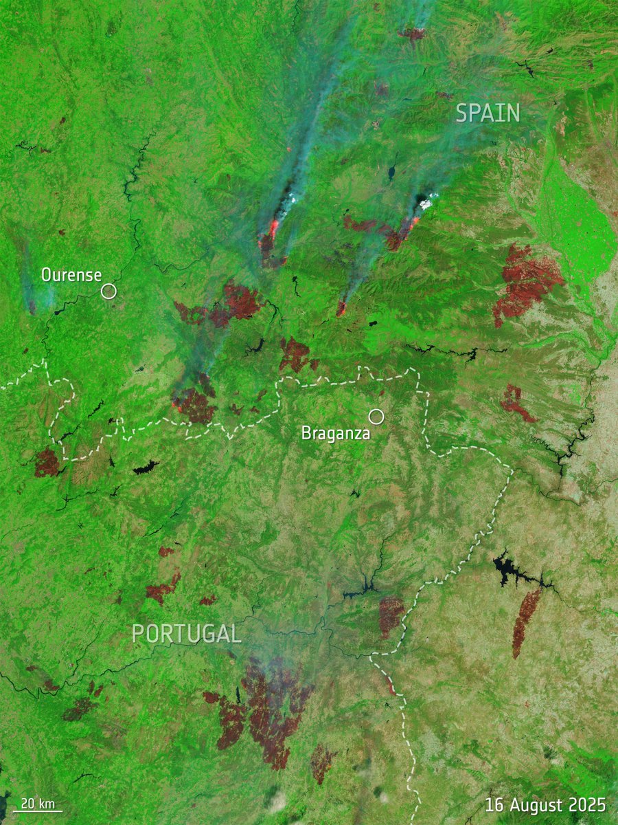
Soaring temperatures and dry land have fuelled widespread wildfires in Southern Europe, with Spain and Portugal among the regions hardest hit: esa.int/Applications/O…

As reported by <a href="/CopernicusECMWF/">Copernicus ECMWF</a>, in the past 6 days emissions for Spain have reached the highest annual total
ESA Earth Observation (@esa_eo) 's Twitter Profile Photo

These two maps span southern Europe, North Africa, the Mediterranean and across to the Black Sea to show fire hotspots (above) and concentrations of atmospheric carbon monoxide (below), on 17 August.

These two maps span southern Europe, North Africa, the Mediterranean and across to the Black Sea to show fire hotspots (above) and concentrations of atmospheric carbon monoxide (below), on 17 August.
ESA Earth Observation (@esa_eo) 's Twitter Profile Photo

🛫 One of the windiest airports in the world: NZWN! Tucked into a narrow inlet to dodge Cook Strait’s roaring winds, Wellington International Airport still contends with intense turbulence. Located on New Zealand’s North Island, it serves the vibrant capital city of Wellington.

🛫 One of the windiest airports in the world: NZWN! 

Tucked into a narrow inlet to dodge Cook Strait’s roaring winds, Wellington International Airport still contends with intense turbulence.
Located on New Zealand’s North Island, it serves the vibrant capital city of Wellington.
ESA Earth Observation (@esa_eo) 's Twitter Profile Photo

Hidden beneath Antarctica’s ice, scientists have identified 85 new subglacial lakes using ESA's CryoSat mission data. Subglacial lakes influence glacier mobility and stability, which can affect sea-level rise, and monitoring them and their cycles adds valuable data for climate models.

Hidden beneath Antarctica’s ice, scientists have identified 85 new subglacial lakes using <a href="/esa_cryosat/">ESA's CryoSat mission</a> data.

Subglacial lakes influence glacier mobility and stability, which can affect sea-level rise, and monitoring them and their cycles adds valuable data for climate models.
ESA Earth Observation (@esa_eo) 's Twitter Profile Photo

A volcanic island with pink beaches and dragons🐉 This Copernicus EU Sentinel-2 image shows Komodo Island 🇮🇩, home to the world’s largest living lizard, the Komodo dragon. Part of Komodo National Park, a UNESCO World Heritage Site, the island sits within the Coral Triangle,

A volcanic island with pink beaches and dragons🐉 

This <a href="/CopernicusEU/">Copernicus EU</a> Sentinel-2 image shows Komodo Island 🇮🇩, home to the world’s largest living lizard, the Komodo dragon.

Part of Komodo National Park, a UNESCO World Heritage Site, the island sits within the Coral Triangle,
ESA Earth Observation (@esa_eo) 's Twitter Profile Photo

This Copernicus EU Sentinel-2 image shows part of Northeast Greenland National Park, the world’s largest national park. Dove Bay (right) is partly ice-free with seasonal breakup fractures, caused by wind and currents. In the top right corner is Danmarkshavn weather station, one

This <a href="/CopernicusEU/">Copernicus EU</a> Sentinel-2 image shows part of Northeast Greenland National Park, the world’s largest national park.

Dove Bay (right) is partly ice-free with seasonal breakup fractures, caused by wind and currents. In the top right corner is Danmarkshavn weather station, one
ESA Earth Observation (@esa_eo) 's Twitter Profile Photo

A lava lake from space 🌋 This Copernicus EU Sentinel-2 image shows Kīlauea’s main crater filled with a lava lake about 2.5 km long, after an eruptive episode during September 2025 when lava fountains reached about 100m high. Smoke plumes are visible rising from the crater.

A lava lake from space 🌋

This <a href="/CopernicusEU/">Copernicus EU</a> Sentinel-2 image shows Kīlauea’s main crater filled with a lava lake about 2.5 km long, after an eruptive episode during September 2025 when lava fountains reached about 100m high.
Smoke plumes are visible rising from the crater.
ESA Earth Observation (@esa_eo) 's Twitter Profile Photo

Satellites have captured the largest ocean swells ever measured from space, averaging nearly 20 metres high🌊 In a new study, scientists used data from ESA Climate Office’s Sea State project and the SWOT mission to improve wave models and better understand how these long waves travel
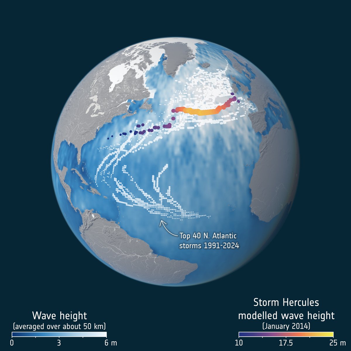
Satellites have captured the largest ocean swells ever measured from space, averaging nearly 20 metres high🌊

In a new study, scientists used data from <a href="/esaclimate/">ESA Climate Office</a>’s Sea State project and the SWOT mission to improve wave models and better understand how these long waves travel
ESA Earth Observation (@esa_eo) 's Twitter Profile Photo

Let's take a look back at when Cyclone Errol was heading towards the coast of Western Australia on 16 April. In this Copernicus EU Sentinel-3 image, the typical pinhole eye – a small, well-defined eye often associated with powerful and rapidly intensifying tropical cyclones –
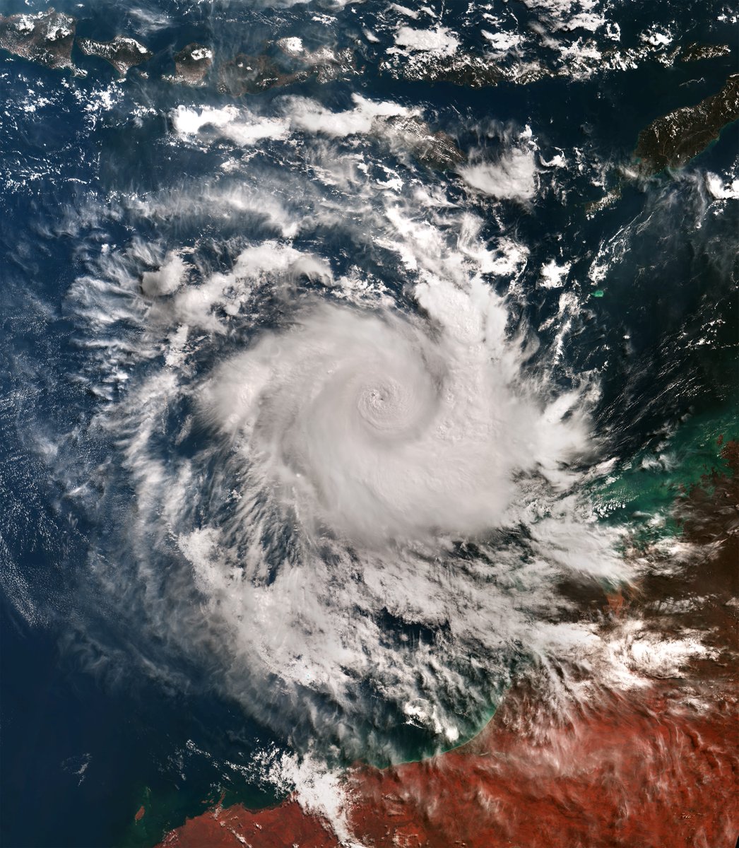
Let's take a look back at when Cyclone Errol was heading towards the coast of Western Australia on 16 April. 

In this <a href="/CopernicusEU/">Copernicus EU</a> Sentinel-3 image, the typical pinhole eye – a small, well-defined eye often associated with powerful and rapidly intensifying tropical cyclones –
ESA Earth Observation (@esa_eo) 's Twitter Profile Photo

The South Atlantic Anomaly, a weak region in Earth’s magnetic field, is expanding. Using data from ESA's Swarm mission, an Earth Explorer mission within European Space Agency’s FutureEO programme, scientists have found that the region has grown by an area almost half the size of Europe since 2014. Read
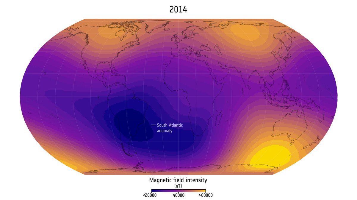
The South Atlantic Anomaly, a weak region in Earth’s magnetic field, is expanding.

Using data from <a href="/esa_swarm/">ESA's Swarm mission</a>, an Earth Explorer mission within <a href="/esa/">European Space Agency</a>’s FutureEO programme, scientists have found that the region has grown by an area almost half the size of Europe since 2014. 

Read