Michael Eichmann (@mieichmann) 's Twitter Profile
Michael Eichmann

@mieichmann

ID: 3021241373

calendar_today06-02-2015 09:59:56

446 Tweet

55 Followers

164 Following

Extreme Temperatures Around The World (@extremetemps) 's Twitter Profile Photo

THIS IS CRAZY ! (NOT April joke) 35 Torregrotta ITALY 33 Montana BULGARIA 31.8 Negotin SERBIA 31.6 Tirana ALBANIA 31 Focsani ROMANIA 30.2 Kelebia HUNGARY 30.2 Bravicea MOLDOVA 30.1 Osijek CROATIA 29.3 Mohyliv UKRAINE 28.5 Vienna AUSTRIA 27.6 Cerklje SLOVENIA 27.2 Dudince SLOVAKIA

THIS IS CRAZY ! (NOT April joke)
35 Torregrotta ITALY
33 Montana BULGARIA
31.8 Negotin SERBIA
31.6 Tirana ALBANIA
31 Focsani ROMANIA
30.2 Kelebia HUNGARY
30.2 Bravicea MOLDOVA
30.1 Osijek CROATIA
29.3 Mohyliv UKRAINE
28.5 Vienna AUSTRIA
27.6 Cerklje SLOVENIA
27.2 Dudince SLOVAKIA
Philip Klotzbach (@philklotzbach) 's Twitter Profile Photo

Atlantic seasonal #hurricane forecast from Colorado State University calls for very active season: 23 named storms, 11 hurricanes & 5 major hurricanes. Extremely warm tropical Atlantic and likely #LaNina are the primary reasons. tropical.colostate.edu/Forecast/2024-…
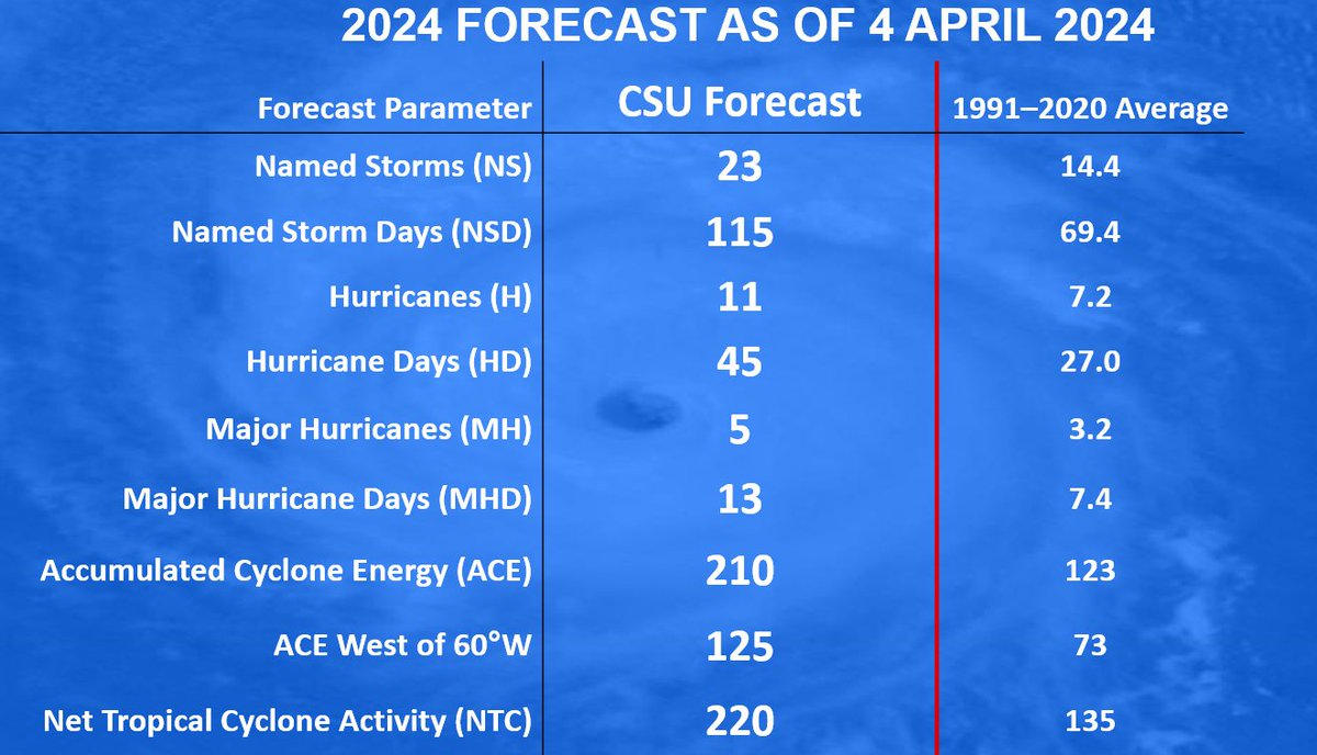
Atlantic seasonal #hurricane forecast from <a href="/ColoradoStateU/">Colorado State University</a> calls for very active season: 23 named storms, 11 hurricanes &amp; 5 major hurricanes. Extremely warm tropical Atlantic and likely #LaNina are the primary reasons.

tropical.colostate.edu/Forecast/2024-…
DWD Klima und Umwelt (@dwd_klima) 's Twitter Profile Photo

Kommt es zumindest gefühlt zu mehr #Saharastaub-Ereignissen oder wird einfach nur mehr darüber berichtet? Nach Messungen unseres Observatoriums Hohenpeißenberg gibt es ausgeprägte Jahr-zu-Jahr-Schwankungen, aber keinen signifikanten Trend. dwd.de/DE/forschung/a…

Kommt es zumindest gefühlt zu mehr #Saharastaub-Ereignissen oder wird einfach nur mehr darüber berichtet? Nach Messungen unseres Observatoriums Hohenpeißenberg gibt es ausgeprägte Jahr-zu-Jahr-Schwankungen, aber keinen signifikanten Trend. 
dwd.de/DE/forschung/a…
Ben Noll (@bennollweather) 's Twitter Profile Photo

78% of Earth's oceans are currently experiencing a marine heatwave (MHW) 🌡️ 🌊 The event in the Mediterranean & Black Sea is extreme. MHWs near the UK & southwest of Spain may be of significance to the relentless rains in the UK, as air flows over these en route to the country.

78% of Earth's oceans are currently experiencing a marine heatwave (MHW) 🌡️ 🌊

The event in the Mediterranean &amp; Black Sea is extreme.

MHWs near the UK &amp; southwest of Spain may be of significance to the relentless rains in the UK, as air flows over these en route to the country.
Cameron Nixon (@cameronjnixon) 's Twitter Profile Photo

Since the cat's (mostly) out of the bag, here's some goodies from my most recent work In the 30 mins before tornadogenesis, tornadic supercells tend to have: - cell mergers into their left flanks - increasing cells in their rear flanks - decreasing cells in their forward flanks

Zdenek Nejedly (@zdeneknejedly) 's Twitter Profile Photo

-80.0 °C on the Antarctica station Vostok The lowest April temperature since 1998 and just the 4th time since opening in 1957 -81.8 °C on April 25, 1964 -80.7 °C on April 24, 1981 -80.7 °C on April 19, 1998 p. 28/01/2024, a new complex at the Vostok station was opened

-80.0 °C on the Antarctica station Vostok
The lowest April temperature since 1998 and just the 4th time since opening in 1957
-81.8 °C on April 25, 1964
 -80.7 °C on April 24, 1981
 -80.7 °C on April 19, 1998

p.  28/01/2024, a new complex at the Vostok station was opened
Evan Bentley (@evan_bentley) 's Twitter Profile Photo

Preliminary tornado tracks from NWS PNSs from the April 25 to April 28 tornado outbreak sequence. 25 EF2+ tornadoes 9 EF3+ tornadoes 1 EF4 tornado Note: Tornadoes without a PNS or a malformed PNS may not be included.

Preliminary tornado tracks from NWS PNSs from the April 25 to April 28 tornado outbreak sequence. 

25 EF2+ tornadoes
9 EF3+ tornadoes
1 EF4 tornado

Note: Tornadoes without a PNS or a malformed PNS may not be included.
Tucker Antico (@tuckerweather) 's Twitter Profile Photo

In this 45 minute loop from SW OK, we've witnessed... 1) RFD surge initiate a strong tornado 2) TVS with GTG shear of 260+ MPH (600 FT beam height) 3) Tornado retrograde as it occluded 4) "Hurricane eye" BWER 5) Strong anticyclonic tornado emerge to the south #OKwx

Brian Emfinger (@brianemfinger) 's Twitter Profile Photo

Here’s my view of the rain wrapped confirmed tornado E of Okeene. You could tell by the storm rotation there was something back in there. #okwx

Prof Hayley J. Fowler (@hayleyjfowler) 's Twitter Profile Photo

Our new paper out today in Climate Dynamics provides a new climatology of hail in Europe led by Abdullah Kahraman using a convection permitting climate model. We have also investigated future changes, to come! #ClimateCrisis Engineering at Newcastle Met Office link.springer.com/article/10.100…

Reed Timmer, PhD (@reedtimmerusa) 's Twitter Profile Photo

STRONGEST #TORNADO IN HISTORY? 300+ mph wind confirmed in Greenfield, Iowa tornado. Check out this new drone footage from this prior to this measurement! WATCH: youtu.be/o_kms2m5V-Q?si…

NOAA Aircraft Operations Center (@noaa_hurrhunter) 's Twitter Profile Photo

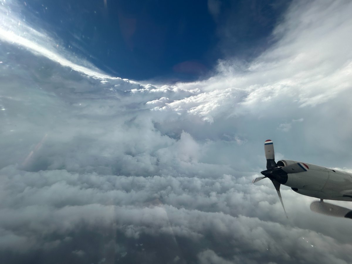
OVER THE CARIBBEAN - Inside the eye of Category 5 Hurricane #Beryl! NOAA WP-3D Orion #NOAA43 “Miss Piggy” continues operations into Hurricane #Beryl to collect data for hurricane forecasting and research. Visit hurricanes.gov for the latest forecast and advisories.

OVER THE CARIBBEAN - Inside the eye of Category 5 Hurricane #Beryl!
NOAA WP-3D Orion #NOAA43 “Miss Piggy” continues operations into Hurricane #Beryl to collect data for hurricane forecasting and research.
Visit hurricanes.gov for the latest forecast and advisories.
Tomer Burg (@burgwx) 's Twitter Profile Photo

We now have enough recon data over the last few days to construct a swath of the peak flight-level wind of Hurricane Beryl - here's an overview of its structural evolution:

We now have enough recon data over the last few days to construct a swath of the peak flight-level wind of Hurricane Beryl - here's an overview of its structural evolution:
Philip Klotzbach (@philklotzbach) 's Twitter Profile Photo

#Hurricane #Beryl continues to rapidly track towards Jamaica as a Category 4 hurricane with max winds of 145 mph. The last major hurricane to track within 50 miles of Jamaica is Hurricane Dean (2007). bit.ly/4f214hN

Steve Caparotta, Ph.D. (@stevewafb) 's Twitter Profile Photo

The GRAF model continues to show #Beryl rapidly organizing Sunday into Monday upon approach to Texas. It's also on the northern end of our current guidance envelope, so those near Houston should still watch closely. GRAF has often done well w/ tropical systems in recent years.

London & Southeast 🔆 (@thesnowdreamer) 's Twitter Profile Photo

Interesting this, map showing the climatological peak of summer in Europe. On average the warmest days of summer are over in Northern Europe. In next few days much of Europe including UK joins them, notice the coastal areas lag behind as bodies of water take longer to cool

Interesting this, map showing the climatological peak of summer in Europe. 

On average the warmest days of summer are over in Northern Europe. In next few days much of Europe including UK joins them, notice the coastal areas lag behind as bodies of water take longer to cool
Scott Duncan (@scottduncanwx) 's Twitter Profile Photo

Flooding disaster unfolding right now in Central Europe. Why is it so bad? This thread takes a quick look at some of the key ingredients of this record-breaking storm.

Flooding disaster unfolding right now in Central Europe.

Why is it so bad? 

This thread takes a quick look at some of the key ingredients of this record-breaking storm.