Mike Wulder (@mikewulder) 's Twitter Profile
Mike Wulder

@mikewulder

Senior Research Scientist with the Canadian Forest Service. 🍁
#Landsat super-fan. #Lidar. #Forests. #Remotesensing. 🌲🛰
Member of the #OrderOfCanada. 🎖

ID: 400409011

linkhttps://www.researchgate.net/profile/Michael_Wulder calendar_today29-10-2011 00:24:00

5,5K Tweet

13,13K Followers

6,6K Following

Mike Wulder (@mikewulder) 's Twitter Profile Photo

Whorl detector extracts branching info of standing timber to predict internal wood quality. Pehkonen et al. Identification and segmentation of branch whorls and sawlogs in standing timber using terrestrial laser scanning and deep learning. Forestry - An Int. Journal of Forest Research 🔗 doi.org/10.1093/forest…
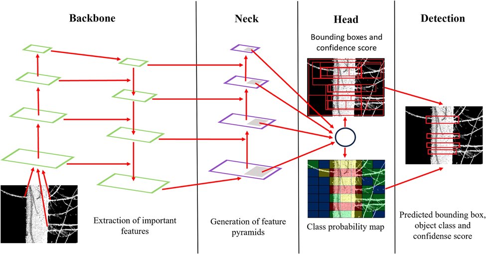

Whorl detector extracts branching info of standing timber to predict internal wood quality.
Pehkonen et al. Identification and segmentation of branch whorls and sawlogs in standing timber using terrestrial laser scanning and deep learning. <a href="/Forestry_OUP/">Forestry - An Int. Journal of Forest Research</a>
🔗 doi.org/10.1093/forest…
NASAEarthdata (@nasaearthdata) 's Twitter Profile Photo

NASA's HLS project has released new vegetation indices with 30m spatial resolution, enhancing global monitoring for agricultural and other vegetation-focused applications. Dive into the data: earthdata.nasa.gov/news/harmonize… #Vegetation #Agriculture #Nasa

NASA's HLS project has released new vegetation indices with 30m spatial resolution, enhancing global monitoring for agricultural and other vegetation-focused applications. 

Dive into the data: earthdata.nasa.gov/news/harmonize…
#Vegetation #Agriculture #Nasa
Mike Wulder (@mikewulder) 's Twitter Profile Photo

"Since 2000, glaciers have lost between 2% and 39% of their ice regionally and about 5% globally." Zemp et al (The GlaMBIE Team). Community estimate of global glacier mass changes from 2000 to 2023. 🔗 nature.com/articles/s4158…

"Since 2000, glaciers have lost between 2% and 39% of their ice regionally and about 5% globally."
Zemp et al (The GlaMBIE Team). Community estimate of global glacier mass changes from 2000 to 2023.
🔗 nature.com/articles/s4158…
Forestry - An Int. Journal of Forest Research (@forestry_oup) 's Twitter Profile Photo

For our new special issue on forest fires in cool-temperate and humid-continental forest, Ewald and colleagues wrote a review laying out the context of this special issue. Why focus on 🔥 in these regions? What are some knowledge gaps? Read here 👇 doi.org/10.1093/forest…

For our new special issue on forest fires in cool-temperate and humid-continental forest, Ewald and colleagues wrote a review laying out the context of this special issue.

Why focus on 🔥 in these regions?
What are some knowledge gaps?

Read here 👇
doi.org/10.1093/forest…
USGS Landsat (@usgslandsat) 's Twitter Profile Photo

The USGS, in partnership with NASA, is inviting civil employees of U.S. Federal agencies and international partner organizations to serve on the 2025-2030 #Landsat Science Team. The application deadline has been extended to March 14, 2025. Learn more here: ow.ly/FjvC50V7N85

The USGS, in partnership with NASA, is inviting civil employees of U.S. Federal agencies and international partner organizations to serve on the 2025-2030 #Landsat Science Team. The application deadline has been extended to March 14, 2025. Learn more here: ow.ly/FjvC50V7N85
Mike Wulder (@mikewulder) 's Twitter Profile Photo

🚨Context, review, insights and direction- paper has it all! Dr. Joanne C. White et al. Enhanced forest inventories in Canada: implementation, status, and research needs. 🔗cdnsciencepub.com/doi/10.1139/cj… Plus, stay current with updated #lidar coverage status maps: ptompalski.github.io/CanadaForestLi…
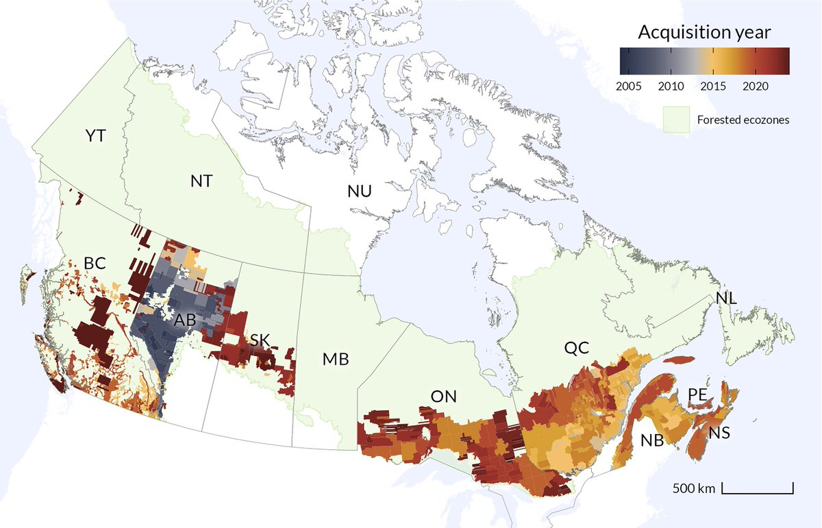
🚨Context, review, insights and direction- paper has it all! 
<a href="/Joanne_C_White/">Dr. Joanne C. White</a> et al. Enhanced forest inventories in Canada: implementation, status, and research needs.
🔗cdnsciencepub.com/doi/10.1139/cj…
Plus, stay current with updated #lidar coverage status maps:
ptompalski.github.io/CanadaForestLi…
Mike Wulder (@mikewulder) 's Twitter Profile Photo

Total area of #lidar (ALS) coverage in Canada is 1,768,170 km2, or 19.4% of the total land area. Coverage of forested ecozones is ~27.2%, while coverage of managed forests is ~66.2%. Up-to-date coverage stats: ptompalski.github.io/CanadaForestLi… Paper: White et al. cdnsciencepub.com/doi/10.1139/cj…
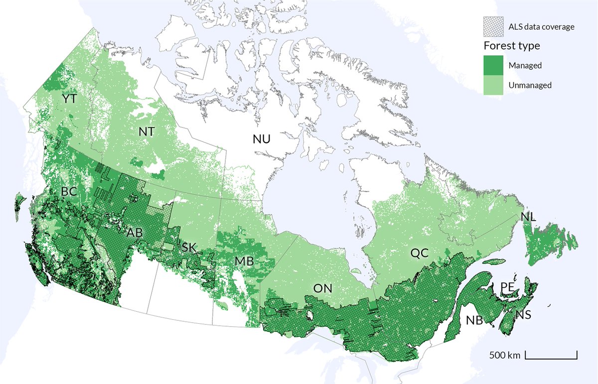

Total area of #lidar (ALS) coverage in Canada is 1,768,170 km2, or 19.4% of the total land area. Coverage of forested ecozones is ~27.2%, while coverage of managed forests is ~66.2%. 
Up-to-date coverage stats: ptompalski.github.io/CanadaForestLi…
Paper: White et al.  cdnsciencepub.com/doi/10.1139/cj…
USGS EROS (@usgs_eros) 's Twitter Profile Photo

The Annual NLCD Science Product User Guide serves as a comprehensive resource for understanding the #AnnualNLCD product suite. For those seeking more information about this new #LandCover product, this guide is an invaluable resource. Check it out here: ow.ly/WAR550Vawky

Bishop's University (@ubishops) 's Twitter Profile Photo

Wrapping up Bishop’s Research Week 2025!  The week was a celebration of innovation and discovery. Congratulations to our student competition winners—your hard work and curiosity are what research is all about! Thank you to everyone who made this year unforgettable!

Wrapping up Bishop’s Research Week 2025! 

The week was a celebration of innovation and discovery.
Congratulations to our student competition winners—your hard work and curiosity are what research is all about!

Thank you to everyone who made this year unforgettable!
NASA Landsat (@nasa_landsat) 's Twitter Profile Photo

What is a satellite 'underfly'? 🛰️ Early in its mission life, #Landsat 9 flew directly under Landsat 8, and the two imaged Earth simultaneously. This allowed scientists to cross-calibrate the instruments, ensuring accurate and consistent data for long-term Earth observation.

Forestry - An Int. Journal of Forest Research (@forestry_oup) 's Twitter Profile Photo

Have you seen our collection of high-impact articles? Take a look at the most read and cited papers of the last two years at Forestry with topics ranging from: 🛰️ Remote sensing 💻 Deep learning 📈 Carbon stocks and more! academic.oup.com/forestry/pages…

Mohammadali Hemati (@hemati_) 's Twitter Profile Photo

I am thrilled to announce that I have started my role as an IEEE Geoscience and Remote Sensing Society YP Ambassador! I look forward to engaging more with the geoscience and remote sensing community, collaborating with fellow professionals, and contributing to the growth of this incredible field. #IEEE #GRSS

USGS Landsat (@usgslandsat) 's Twitter Profile Photo

The GOLD standard is the goal of the USGS EROS CalVal Center of Excellence #Landsat Cal/Val team. Experts focus on improving the accuracy, precision, calibration, & quality of data acquired by active Landsat missions publish their findings in reports: ow.ly/GH4J50VruLS.

The GOLD standard is the goal of the USGS EROS CalVal Center of Excellence #Landsat Cal/Val team.  Experts focus on improving the accuracy, precision, calibration, &amp; quality of data acquired by active Landsat missions publish their findings in reports: ow.ly/GH4J50VruLS.
USGS Landsat (@usgslandsat) 's Twitter Profile Photo

Geometric and radiometric calibration are the backbone of #Landsat's exceptional #DataQuality. The USGS and NASA continually monitor the geometric and radiometric performance of instruments to maintain data quality at the highest level. Learn more here: ow.ly/tnLa50VxwYq.

Geometric and radiometric calibration are the backbone of #Landsat's exceptional #DataQuality. The <a href="/USGS/">USGS</a> and <a href="/NASA/">NASA</a> continually monitor the geometric and radiometric performance of instruments to maintain data quality at the highest level. Learn more here: ow.ly/tnLa50VxwYq.
SkogRover (@skogrover) 's Twitter Profile Photo

Big thanks to our invited speakers—research scientist Joanne White and senior scientist Lauri Korhonen—for their excellent presentations today at our seminar on forest inventory and monitoring. Tomorrow, they will act as opponents at Jaime Candelas Bielza's doctoral defense.

Big thanks to our invited speakers—research scientist Joanne White and senior scientist Lauri Korhonen—for their excellent presentations today at our seminar on forest inventory and monitoring. Tomorrow, they will act as opponents at Jaime Candelas Bielza's doctoral defense.
Mike Wulder (@mikewulder) 's Twitter Profile Photo

Announcement: Remote Sensing of Environment, Special Issue: ➡️Development, Validation, and Application of Medium- and High-Resolution Satellite Products at Regional to Global Scales Builds on Radeloff et al. 2024 (113918) data products review in RSE. See: sciencedirect.com/special-issue/…

Announcement:  Remote Sensing of Environment, Special Issue:
➡️Development, Validation, and Application of Medium- and High-Resolution Satellite Products at Regional to Global Scales
Builds on Radeloff et al. 2024 (113918) data products review in RSE.
See: sciencedirect.com/special-issue/…
Mike Wulder (@mikewulder) 's Twitter Profile Photo

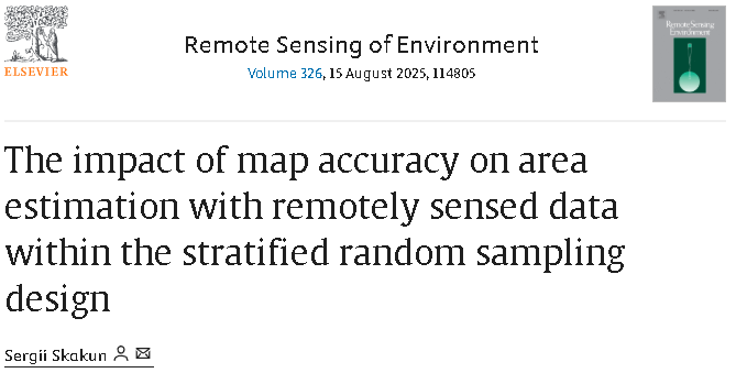
🛰️ Ever wonder how classification errors in remote sensing derived maps influence area estimates in stratified random sampling? 🤔 A new study explores the impact of map accuracy on area estimation and offers methods to mitigate biases. #landcover #landuse doi.org/10.1016/j.rse.…

🛰️ Ever wonder how classification errors in remote sensing derived maps influence area estimates in stratified random sampling? 🤔
A new study explores the impact of map accuracy on area estimation and offers methods to mitigate biases.
#landcover #landuse
doi.org/10.1016/j.rse.…
USGS Landsat (@usgslandsat) 's Twitter Profile Photo

The Landsat Archive Dashboard lets us explore and examine the number and volume of Landsat Collection 2 Level-1 and Level-2 products held in the USGS archive. Check out the interactive dashboard to dig in: ow.ly/2lJH50SQk4C.

Di Long (@dilong5) 's Twitter Profile Photo

Our study "Global dominance of seasonality in shaping lake-surface-extent dynamics" is now published in nature. We reveal how seasonal rhythms govern the dynamics of ~1.4 million lakes globally. 🔗 nature.com/articles/s4158… #ClimateChange #RemoteSensing #Hydrology #LakeDynamic

Mike Wulder (@mikewulder) 's Twitter Profile Photo

NEW! Title captures science well. 👇 Ye et al. A multi-resolution forest stand segmentation algorithm integrating Landsat imagery and forest structural, age, and species attributes. Integrated RS Studio #Landsat #landcover #NTEMS #OpenAccess: sciencedirect.com/science/articl…

NEW! Title captures science well. 👇
Ye et al. A multi-resolution forest stand segmentation algorithm integrating Landsat imagery and forest structural, age, and species attributes.
<a href="/IRSS_UBC/">Integrated RS Studio</a> #Landsat #landcover #NTEMS
#OpenAccess:  sciencedirect.com/science/articl…