Dr. Matheus Pinheiro Ferreira (@mpferreira3) 's Twitter Profile
Dr. Matheus Pinheiro Ferreira

@mpferreira3

Professor of Forest Sciences at University of São Paulo (USP) interested in innovative technologies for monitoring tropical ecosystems (He/Him/His)

ID: 1258078129

linkhttps://sites.google.com/usp.br/mpferreira/home calendar_today10-03-2013 22:13:27

319 Tweet

1,1K Followers

1,1K Following

Michael White (@mwclimatesci) 's Twitter Profile Photo

I’ve handled the review of > 1000 papers at @nature. Over time, you notice aspects of presentation on which reviewers tend to comment. In the interests of minimizing hassles during review, I offer the following suggestions (a bit targeted to climate papers).

Andrew Akbashev (@andrew_akbashev) 's Twitter Profile Photo

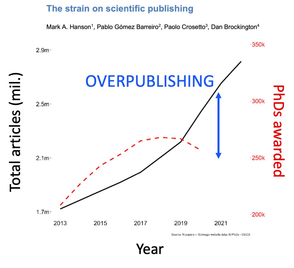
Overpublishing puts enormous stress on students and PIs. And brings tons of money to publishers in STEM. A new study shows that the number of papers is increasing FASTER than the number of #PhD graduates. It’s an amazing work with very useful statistics. Huge kudos to the

Overpublishing puts enormous stress on students and PIs.

And brings tons of money to publishers in STEM.

A new study shows that the number of papers is increasing FASTER than the number of #PhD graduates.

It’s an amazing work with very useful statistics. Huge kudos to the
ForestSAT (@forestsat) 's Twitter Profile Photo

Now accepting nominations for the Thomas Hilker Early Career Scientist Award! Learn more about Thomas and this award which recognizes not only productivity and scientific rigor but also humility, service, and collaboration. forestsat.com/thomas-hilker-…

Now accepting nominations for the Thomas Hilker Early Career Scientist Award!  Learn more about Thomas and this award which recognizes not only productivity and scientific rigor but also humility, service, and collaboration.
forestsat.com/thomas-hilker-…
Ricardo Dalagnol (@ricardodalagnol) 's Twitter Profile Photo

📢🌳New paper led by Fabien Wagner in RSE on tree's height mapping over California with #DeepLearning I really like Fig 7 : it clearly shows how the model predicts height based on optical imagery very close to LiDAR even on STEEP terrain - crazy! 😮 doi.org/10.1016/j.rse.…
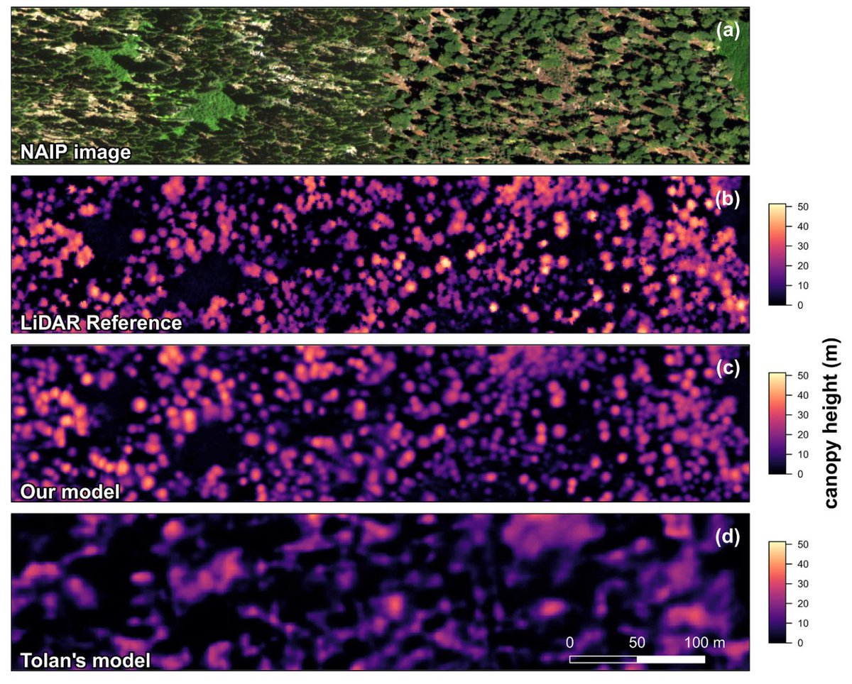
📢🌳New paper led by <a href="/FabienWagner/">Fabien Wagner</a> in RSE on tree's height mapping over California with #DeepLearning 

I really like Fig 7 : it clearly shows how the model predicts height based on optical imagery very close to LiDAR even on STEEP terrain - crazy! 😮

doi.org/10.1016/j.rse.…
Dr. Carlos Alberto Silva 🌲🌍🛰 (@web_lidar) 's Twitter Profile Photo

📢This workshop is part of our #NASA's CMS project. We are looking for partners who are interested in #Carbon, #Fire, and #Tropical Savanna, especially in the Brazilian Cerrado. Check it out here if you are interested in collaborating with us. carlos-alberto-silva.github.io/silvalab/cms4d…

📢This workshop is part of our #NASA's CMS project. We are looking for partners who are interested in #Carbon, #Fire, and #Tropical Savanna, especially in the Brazilian Cerrado. Check it out here if you are interested in collaborating with us.
carlos-alberto-silva.github.io/silvalab/cms4d…
Qiusheng Wu (@giswqs) 's Twitter Profile Photo

Meta AI just released Segment Anything Model 2 (SAM 2) 🚀 Time for a SAMGeo upgrade 😀 github.com/facebookresear…

Gilberto Camara (@gcamara) 's Twitter Profile Photo

#Rstats package sits 1.5.1 is now on CRAN! State-of-the-art big Earth observation data analysis with image time series. Check-out the docs at e-sensing.github.io/sitsbook. To learn more, follow the thread.

Dr. Matheus Pinheiro Ferreira (@mpferreira3) 's Twitter Profile Photo

“The 2024 state of the climate report: Perilous times on planet Earth” Great work and important alert to all of us! doi.org/10.1093/biosci…

Clemens Mosig (@clemensmosig) 's Twitter Profile Photo

Checkout our preprint: deadtrees.earth - An Open-Access and Interactive Database for Centimeter-Scale Aerial Imagery to Uncover Global Tree Mortality Dynamics biorxiv.org/content/10.110…

Checkout our preprint: deadtrees.earth - An Open-Access and Interactive Database for Centimeter-Scale Aerial Imagery to Uncover Global Tree Mortality Dynamics

biorxiv.org/content/10.110…
Teja Kattenborn (@tejakattenborn) 's Twitter Profile Photo

With deadtrees.earth we aim to uncover global tree mortality dynamics with satellite data. We use drone data as a reference. The coverage is growing rapidly but is still sparse in Africa and Asia. Join the initiative if you have drone RGB orthoimages of any forest :-)

Dr. Matheus Pinheiro Ferreira (@mpferreira3) 's Twitter Profile Photo

An amazing 3D view of a restinga forest at Ilha do Cardoso, São Paulo, Brazil. LiDAR data acquired using the Hovermap STX mobile LiDAR system. Exciting science ahead with GEO-TREES (geo-trees.org/project/). Jerome Chave

An amazing 3D view of a restinga forest at Ilha do Cardoso, São Paulo, Brazil. LiDAR data acquired using the Hovermap STX mobile LiDAR system. Exciting science ahead with GEO-TREES (geo-trees.org/project/). <a href="/JeromeChave/">Jerome Chave</a>