The National Weather Desk (@natwxdesk) 's Twitter Profile
The National Weather Desk

@natwxdesk

Connecting you with awesome weather content from Sinclair's meteorologists across the country and from our viewers using Chime In. @natwxdesk #WowWeather

ID: 1527282676834742277

linkhttps://bit.ly/TNWDesk calendar_today19-05-2022 13:40:27

5,5K Tweet

1,1K Followers

221 Following

The National Weather Desk (@natwxdesk) 's Twitter Profile Photo

Extensive flooding ongoing in the NYC metro area. Training thunderstorms will continue to produce heavy rainfall over the next several hours.

The National Weather Desk (@natwxdesk) 's Twitter Profile Photo

The past radar estimates over the last 24 hours via NWS State College. Notice much of the Mid-Atlantic received 1-3" of rain. Bullseyes in PA, MD, VA and Northern New Jersey contain totals between 4 - 6" with isolated totals in the Garden State up to 7". #Flood #NJwx #PAwx #MDwx
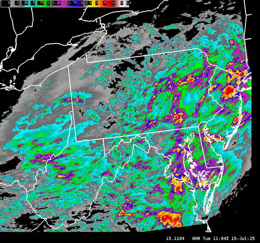
The past radar estimates over the last 24 hours via <a href="/NWSStateCollege/">NWS State College</a>. Notice much of the Mid-Atlantic received 1-3" of rain. Bullseyes in PA, MD, VA and Northern New Jersey contain totals between 4 - 6" with isolated totals in the Garden State up to 7". #Flood #NJwx #PAwx #MDwx
The National Weather Desk (@natwxdesk) 's Twitter Profile Photo

Another round of showers and storms likely across the Northeast today. Since the ground is already extremely saturated and rainfall rates will be high, watch for isolated spots of flash flooding. #flood #flooding

National Weather Service (@nws) 's Twitter Profile Photo

Dangerous heat in the southeast on Saturday will begin to build into the mid-Mississippi Valley and Midwest by early in the upcoming workweek. Major and Extreme HeatRisk are designated for conditions not only to vulnerable populations but also anyone without effective cooling

National Hurricane Center (@nhc_atlantic) 's Twitter Profile Photo

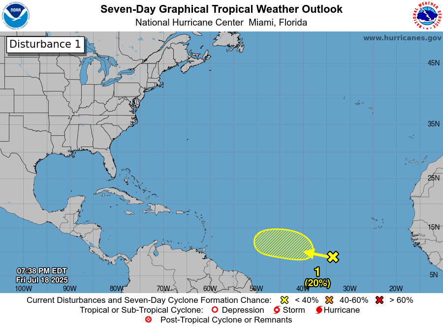
7/18 8pm EDT: A tropical wave interacting with a broad area of low pressure is producing disorganized showers and thunderstorms over the central tropical Atlantic. Slight development is possible late this weekend into early next week as it moves west-northwestward around 10 mph.

7/18 8pm EDT: A tropical wave interacting with a broad area of low pressure is producing disorganized showers and thunderstorms over the central tropical Atlantic. Slight development is possible late this weekend into early next week as it moves west-northwestward around 10 mph.
NWS Weather Prediction Center (@nwswpc) 's Twitter Profile Photo

A dangerous, long-duration heat wave will impact the Southeast, Mid-South, and Midwest through late July. Extreme heat, high humidity, and little overnight relief pose serious health risks. Stay cool, hydrated, and informed: weather.gov/safety/heat

A dangerous, long-duration heat wave will impact the Southeast, Mid-South, and Midwest through late July. Extreme heat, high humidity, and little overnight relief pose serious health risks. Stay cool, hydrated, and informed: weather.gov/safety/heat
National Weather Service (@nws) 's Twitter Profile Photo

Severe thunderstorms and heavy rainfall are likely across parts of the Northeast, portions of the northern and central Plains, and the Ohio Valley. Portions of northeast Missouri and central Illinois could experience locally significant flash flooding. Dangerously hot conditions

Severe thunderstorms and heavy rainfall are likely across parts of the Northeast, portions of the northern and central Plains, and the Ohio Valley. Portions of northeast Missouri and central Illinois could experience locally significant flash flooding. Dangerously hot conditions
The National Weather Desk (@natwxdesk) 's Twitter Profile Photo

This #seaturtle was spotted in #DaytonaBeach heading toward the surf, presumably after laying eggs, this morning. . To submit your own weather and great outdoors content like this, search for your local TV station's #ChimeIn page. . Credit: Angela Elliott

The National Weather Desk (@natwxdesk) 's Twitter Profile Photo

Slim (20%) chance of tropical development in the Atlantic from a tropical wave. The disturbance has ingested African dust and will face wind shear as it moves into the Caribbean. The next name in the #Atlantic hurricane season is Dexter. #Tropicswx National Hurricane Center

The National Weather Desk (@natwxdesk) 's Twitter Profile Photo

An expansive heat wave under a "dome" of high pressure is expected to continue through the end of the week. Temperatures will be extremely high, making for sticky, humid and uncomfortable conditions. If outdoors, wear light colored clothing, stay hydrated and take breaks. #Heat

National Hurricane Center (@nhc_atlantic) 's Twitter Profile Photo

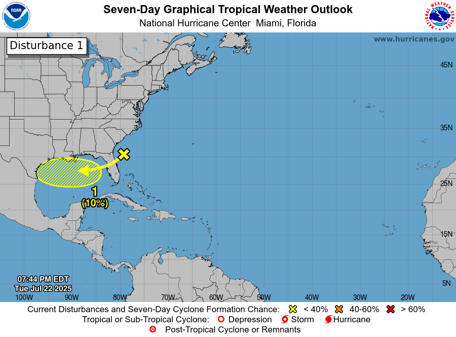
8pm EDT 22 July -- A trough of low pressure, currently located off the SE U.S. coast is forecast to move into the North-Central Gulf, and has a low chance (10%🟡) of tropical cyclone formation before it moves inland by this weekend. Latest Outlook: hurricanes.gov/gtwo.php?basin…

8pm EDT 22 July -- A trough of low pressure, currently located off the SE U.S. coast is forecast to move into the North-Central Gulf, and has a low chance (10%🟡) of tropical cyclone formation before it moves inland by this weekend.

Latest Outlook: hurricanes.gov/gtwo.php?basin…
NWS Atlanta (@nwsatlanta) 's Twitter Profile Photo

Today is considered the peak of the "dog days of summer." The dog days get their name based on astronomy. In ancient times, many cultures believed exceptionally hot weather was directly related to the appearance of Sirius - the "dog star." (1/2)

Today is considered the peak of the "dog days of summer." The dog days get their name based on astronomy. In ancient times, many cultures believed exceptionally hot weather was directly related to the appearance of Sirius - the "dog star." (1/2)
Thomas Geboy (@thomasgeboywx) 's Twitter Profile Photo

Heavy rain resulting in some street flooding in Orange Beach this afternoon. Rain chances will remain elevated the next few days and there will be a marginal excessive rainfall risk for our area both Thursday and Friday. Video from Mallory Landefeld. NBC 15 News NWS Mobile