NOAA's Ocean Service (@noaaocean) 's Twitter Profile
NOAA's Ocean Service

@noaaocean

We are the nation's premier federal science agency for the ocean and our coasts. An official @NOAA account: oceanservice.noaa.gov/socialmedia.ht…

ID: 16878156

linkhttp://oceanservice.noaa.gov calendar_today21-10-2008 00:43:08

10,10K Tweet

207,207K Followers

275 Following

NOAA's Ocean Service (@noaaocean) 's Twitter Profile Photo

Today is the anniversary of D-Day, the largest amphibious landing in WWII. Ocean tides played a crucial role in the historic day - hear the story from an oceanographer: oceanservice.noaa.gov/podcast/june20… 📷: U.S. Army

Today is the anniversary of D-Day, the largest amphibious landing in WWII. Ocean tides played a crucial role in the historic day - hear the story from an oceanographer: oceanservice.noaa.gov/podcast/june20… 
📷: <a href="/USArmy/">U.S. Army</a>
NOAA's Ocean Service (@noaaocean) 's Twitter Profile Photo

We are celebrating World Ocean Day today! Learn more about the vast body of water that covers 71% of Earth: oceanservice.noaa.gov/news/ocean-mon…

NOAA (@noaa) 's Twitter Profile Photo

Just in: NOAA scientists forecast average summer 'dead zone' in Gulf of America. Low-oxygen conditions expected to impact 5,574-square-mile area. More: oceanservice.noaa.gov/news/jun25/dea… via NOAA's Ocean Service #GulfOfAmerica #DeadZone #hypoxia

Just in: NOAA scientists forecast  average summer 'dead zone' in Gulf of America.

Low-oxygen conditions expected to impact 5,574-square-mile area.

More: oceanservice.noaa.gov/news/jun25/dea…

via <a href="/noaaocean/">NOAA's Ocean Service</a>   
#GulfOfAmerica  #DeadZone #hypoxia
NOAA's Ocean Service (@noaaocean) 's Twitter Profile Photo

Before GPS, people found their way with maps and charts… For 125 years, this printing press was used by NOAA and our predecessors to duplicate maps from etched copper plates. Learn more about this fascinating artifact: noaa.gov/heritage/stori…

Before GPS, people found their way with maps and charts…

For 125 years, this printing press was used by NOAA and our predecessors to duplicate maps from etched copper plates.

Learn more about this fascinating artifact:
noaa.gov/heritage/stori…
NOAA's Ocean Service (@noaaocean) 's Twitter Profile Photo

It’s #WorldSeaTurtleDay! Marine debris is a major threat to sea turtles in U.S. waters, like this one trapped in an abandoned fishing net. If you see a sick, injured, stranded sea turtle or other marine mammal, immediately contact your local stranding network:

NOAA's Ocean Service (@noaaocean) 's Twitter Profile Photo

If you're headed to the beach on International Picnic Day, remember to be prepared and stay aware! Find your beach's weather forecast, learn to escape a rip current, and avoid hazards with our guide to beach safety: oceanservice.noaa.gov/.../beach.../w… Photo credit: Peter Pearsall/U.S. Fish and Wildlife Service

If you're headed to the beach on International Picnic Day, remember to be prepared and stay aware! Find your beach's weather forecast, learn to escape a rip current, and avoid hazards with our guide to beach safety: oceanservice.noaa.gov/.../beach.../w…
Photo credit: Peter Pearsall/<a href="/USFWS/">U.S. Fish and Wildlife Service</a>
NOAA's Ocean Service (@noaaocean) 's Twitter Profile Photo

Happy Horseshoe Crab Day! Did you know horseshoe crabs are not even crabs? They’re actually closer cousins to spiders or scorpions! Watch this video to learn more about a this remarkable creature whose ancestors roamed the earth over 450 million years ago: oceantoday.noaa.gov/fullmoon-remar…

NOAA's Ocean Service (@noaaocean) 's Twitter Profile Photo

Do you know your Blue IQ? Watch our new series to learn how to have the best beach day ever - from planning before you go, how to avoid threats in the water, and what to do in a worst-case scenario! oceantoday.noaa.gov/blueiq/welcome…

NOAA's Ocean Service (@noaaocean) 's Twitter Profile Photo

Digging for data? We provide free data on water, tides, currents, and more through APIs and web services. This data provides vital information for safe maritime navigation, emergency response, and recreation: tidesandcurrents.noaa.gov/web_services_i…

Digging for data? We provide free data on water, tides, currents, and more through APIs and web services. This data provides vital information for safe maritime navigation, emergency response, and recreation: tidesandcurrents.noaa.gov/web_services_i…
NOAA Coastal Ocean Science (@noaacoastalsci) 's Twitter Profile Photo

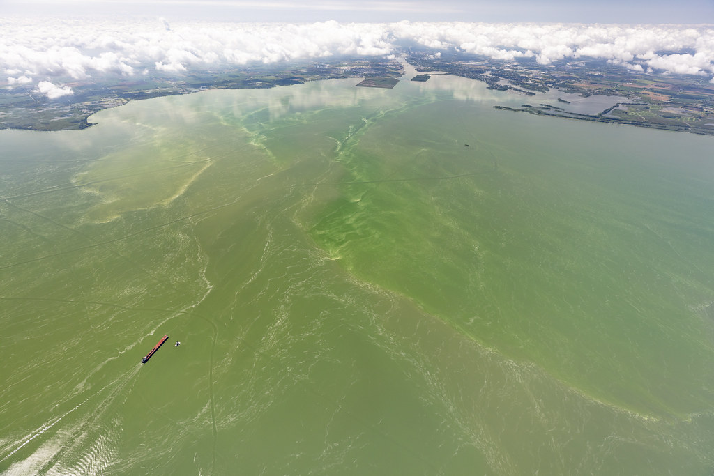
NOAA and partners are forecasting a mild to moderate #HarmfulAlgalBloom for western #LakeErie this summer. The 2025 summer bloom is expected to measure 3, with a potential range of 2 to 4 on the severity index. coastalscience.noaa.gov/news/mild-to-m…

NOAA and partners are forecasting a mild to moderate #HarmfulAlgalBloom for western #LakeErie this summer. The 2025 summer bloom is expected to measure 3, with a potential range of 2 to 4 on the severity index. coastalscience.noaa.gov/news/mild-to-m…
NOAA's Ocean Service (@noaaocean) 's Twitter Profile Photo

Attention beachgoers! Check out our latest podcast before you head out this weekend to learn how to keep yourself and your loved ones safe in the surf: oceanservice.noaa.gov/podcast/june25…

Attention beachgoers! Check out our latest podcast before you head out this weekend to learn how to keep yourself and your loved ones safe in the surf: oceanservice.noaa.gov/podcast/june25…
NOAA Ocean Today (@noaaoceantoday) 's Twitter Profile Photo

Knowing what you don’t know can actually make you the smartest (and safest) person on the shore. Watch to learn how to "read" the beach environment — especially the swash zone, where breaking waves and flowing water can hide rip currents and other hazards: oceantoday.noaa.gov/blueiq/blueiq-…

NOAA's Ocean Service (@noaaocean) 's Twitter Profile Photo

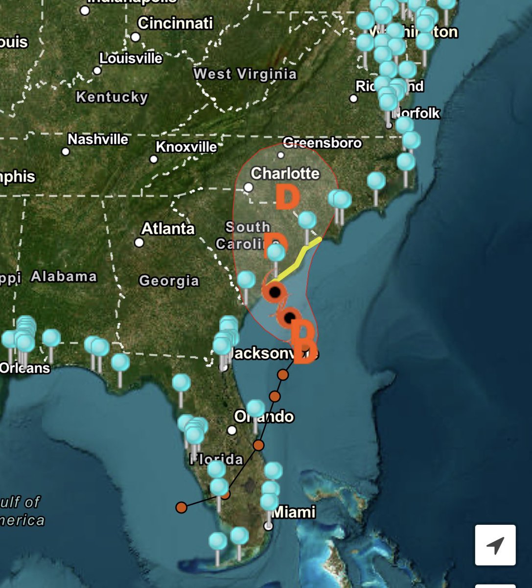
NOAA is monitoring water levels and winds for Tropical Depression Three, forecast to track towards South Carolina. View real-time water level and meteorological data: tidesandcurrents.noaa.gov/inundationdb/c…

NOAA is monitoring water levels and winds for Tropical Depression Three, forecast to track towards South Carolina. View real-time water level and meteorological data: tidesandcurrents.noaa.gov/inundationdb/c…
NHC Storm Surge (@nhc_surge) 's Twitter Profile Photo

7/5 5pm EDT: Coastal flooding due to storm surge from #Chantal is likely along portions of the South Carolina and North Carolina coastline today.

7/5 5pm EDT: Coastal flooding due to storm surge from #Chantal is likely along portions of the South Carolina and North Carolina coastline today.
NOAA's Ocean Service (@noaaocean) 's Twitter Profile Photo

The ocean may look inviting, but every beach has its own hidden dangers. Swimming in the ocean is a completely different sport — and your safety depends on understanding the power of currents, waves, and changing conditions! oceantoday.noaa.gov/blueiq/blueiq-…

NOAA's Ocean Service (@noaaocean) 's Twitter Profile Photo

No, it’s not a steampunk bomb or a high-tech witch’s cauldron. It’s a cosmic-ray meter, designed to detect and measure the levels of cosmic rays in order to help us understand the earth’s magnetic field. Learn about its history here: noaa.gov/heritage/stori… #cosmicrays #physics

No, it’s not a steampunk bomb or a high-tech witch’s cauldron. It’s a cosmic-ray meter, designed to detect and measure the levels of cosmic rays in order to help us understand the earth’s magnetic field.
Learn about its history here:
noaa.gov/heritage/stori…
#cosmicrays #physics
NOAA's Ocean Service (@noaaocean) 's Twitter Profile Photo

NOAA’s National Geodetic Survey (NGS) is collecting aerial damage assessment images following the devastating flooding in the Texas Hill Country. These images are a crucial tool to determine the extent of the damage and will support the recovery efforts of FEMA and our state and

NOAA’s National Geodetic Survey (NGS) is collecting aerial damage assessment images following the devastating flooding in the Texas Hill Country. These images are a crucial tool to determine the extent of the damage and will support the recovery efforts of <a href="/fema/">FEMA</a> and our state and