Chris Bater (@passiveoptical) 's Twitter Profile
Chris Bater

@passiveoptical

ID: 1446995083

calendar_today21-05-2013 18:16:51

185 Tweet

101 Followers

704 Following

Mike Wulder (@mikewulder) 's Twitter Profile Photo

The best-available-pixel (BAP) tool you have been waiting for! Implemented on #GoogleEarthEngine (#GEE). #Landsat In #GEEBAP can tune composite parameters, create a #timeseries, set area of interest, AND download surface reflectance outcomes! Try it out: code.earthengine.google.com/e27240a92ecf64…

The best-available-pixel (BAP) tool you have been waiting for! Implemented on #GoogleEarthEngine (#GEE). #Landsat

In #GEEBAP can tune composite parameters, create a #timeseries, set area of interest, AND download surface reflectance outcomes!

Try it out:
code.earthengine.google.com/e27240a92ecf64…
Integrated RS Studio (@irss_ubc) 's Twitter Profile Photo

NEW PUBLICATION🎉 Estimating tree species composition from #ALS using point-based #deeplearning models #OpenAccess🔓: doi.org/10.1016/j.ispr… ✍️ Brent Murray Coops Lukas Winiwarter Dr. Joanne C. White Adamdick Barbeito Ragab 💰 Natural Resources NSERC / CRSNG #remotesensing @ubcforestry

NEW PUBLICATION🎉

Estimating tree species composition from #ALS using point-based #deeplearning models

#OpenAccess🔓: doi.org/10.1016/j.ispr…

✍️ <a href="/BrentAMurray/">Brent Murray</a> Coops <a href="/geogemgis/">Lukas Winiwarter</a> <a href="/Joanne_C_White/">Dr. Joanne C. White</a> <a href="/adamdick/">Adamdick</a> Barbeito Ragab 
💰 <a href="/NRCan/">Natural Resources</a> <a href="/NSERC_CRSNG/">NSERC / CRSNG</a> 

#remotesensing @ubcforestry
Mike Wulder (@mikewulder) 's Twitter Profile Photo

Canada's new satellite-based forest inventory (#SBFI) uses image segmentation to create detailed, stand-level maps for forest science & monitoring, including tree species and biomass, available via open access. #Landsat Paper: doi.org/10.1093/forest… Data: opendata.nfis.org/mapserver/nfis…

Integrated RS Studio (@irss_ubc) 's Twitter Profile Photo

New Postdoc Opportunity 📢 Interested in #ForestSampling and #LiDAR? Apply to this PDF position and join the IRSS team! 📍@forestry.ubc.ca on Bluesky, Vancouver 📆 Deadline: February 15, 2024 📆 Start date: April 1, 2024 🔗postdocs.ubc.ca/ad/57796 University of British Columbia #RemoteSensing #PDFopportunity #PDFjob

CIF-IFC (@cif_ifc) 's Twitter Profile Photo

NEW E-Lecture Series "Sharing knowledge on some key initiatives happening across the Canadian Forest Service" starting on January 31st 🌲🖥️ Hosted in collaboration with Natural Resources, this 10-lecture series will be presented across three themes. Register now! 👉 cif-ifc.org/what-we-do/e-l…
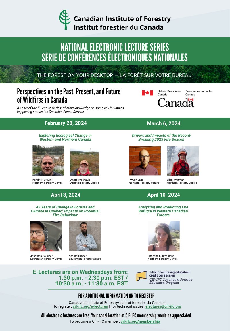

NEW E-Lecture Series "Sharing knowledge on some key initiatives happening across the Canadian Forest Service" starting on January 31st 🌲🖥️ Hosted in collaboration with <a href="/NRCan/">Natural Resources</a>, this 10-lecture series will be presented across three themes. Register now! 👉 cif-ifc.org/what-we-do/e-l…
ABMI (@abbiodiversity) 's Twitter Profile Photo

Do you want to be a leader in lidar? Join the ABMI as the Imaging Centre #Director and lead an experienced team of technicians and programmers in shaping the future of #lidar and #imagery data in #Alberta:ow.ly/zJ6N50QyOTu Deadline is February 26, 2024 #AI#machinelearning

Do you want to be a leader in lidar? Join the ABMI as the Imaging Centre #Director and lead an experienced team of technicians and programmers in shaping the future of #lidar and #imagery data in #Alberta:ow.ly/zJ6N50QyOTu
Deadline is February 26, 2024
#AI#machinelearning
Mike Wulder (@mikewulder) 's Twitter Profile Photo

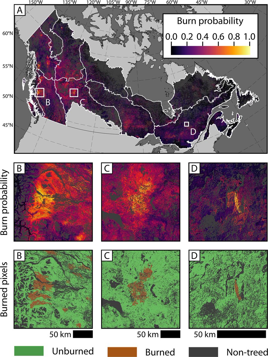
Where & how much #wildfire can be expected?🌲🔥 We use #timeseries #Landsat, #climate, biotic & topographic predictors to model. Mulverhill et al. Multidecadal mapping of status and trends in annual burn probability over Canada’s forested ecosystems. 🔗sciencedirect.com/science/articl…

Where &amp; how much #wildfire can be expected?🌲🔥
We use #timeseries #Landsat, #climate, biotic &amp; topographic predictors to model. 
Mulverhill et al. Multidecadal mapping of status and trends in annual burn probability over Canada’s forested ecosystems.
🔗sciencedirect.com/science/articl…
Dr. Joanne C. White (@joanne_c_white) 's Twitter Profile Photo

📢New paper! Metsaranta et al.: Climate sensitive growth and yield models in Canadian forestry: Challenges and opportunities pubs.cif-ifc.org/doi/abs/10.555… #forest #growth #OpenAccess @cwfc_ccfb @CFS_CAT

📢New paper! Metsaranta et al.: Climate sensitive growth and yield models in Canadian forestry: Challenges and opportunities 
pubs.cif-ifc.org/doi/abs/10.555… 
#forest #growth #OpenAccess @cwfc_ccfb @CFS_CAT
Integrated RS Studio (@irss_ubc) 's Twitter Profile Photo

NEW PAPER 📢 Mapping vegetation height & identifying the northern forest limit across Canada using #ICESat-2, #Landsat time series & topographic data 🛰️ 🔓#OpenAccess: doi.org/10.1016/j.rse.… ✍️ Travers-Smith, Coops, Mulverhill et al 🙏 NSERC / CRSNG University of British Columbia Highlights in 🧵

NEW PAPER 📢

Mapping vegetation height &amp; identifying the northern forest limit across Canada using #ICESat-2, #Landsat time series &amp; topographic data 🛰️

🔓#OpenAccess: doi.org/10.1016/j.rse.…
✍️ Travers-Smith, Coops, Mulverhill et al
🙏 <a href="/NSERC_CRSNG/">NSERC / CRSNG</a> <a href="/UBC/">University of British Columbia</a> 

Highlights in 🧵
Mike Wulder (@mikewulder) 's Twitter Profile Photo

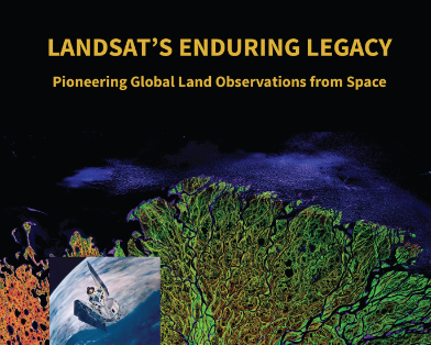
Need a remote sensing text book that is free AND full of useful historic and up-to-date information? 🛰️ Info on what was done, why, & how. Ideal way to learn about #satellite #remotesensing. 🆓#OpenAccess digital version of #Landsat’s Enduring Legacy here: my.asprs.org/landsat

Need a remote sensing text book that is free AND full of useful historic and up-to-date information? 🛰️
Info on what was done, why, &amp; how.
Ideal way to learn about #satellite #remotesensing.
🆓#OpenAccess digital version of #Landsat’s Enduring Legacy here: my.asprs.org/landsat
Mike Wulder (@mikewulder) 's Twitter Profile Photo

🆕.Piotr Tompalski et al. Developing aboveground biomass yield curves for dominant boreal tree species from time series remote sensing data. 📏⏱️🌲 ➡️Models informed by annual biomass values, tree species, and age. #Landsat #carbon #NTEMS #OpenAccess 🔗sciencedirect.com/science/articl…
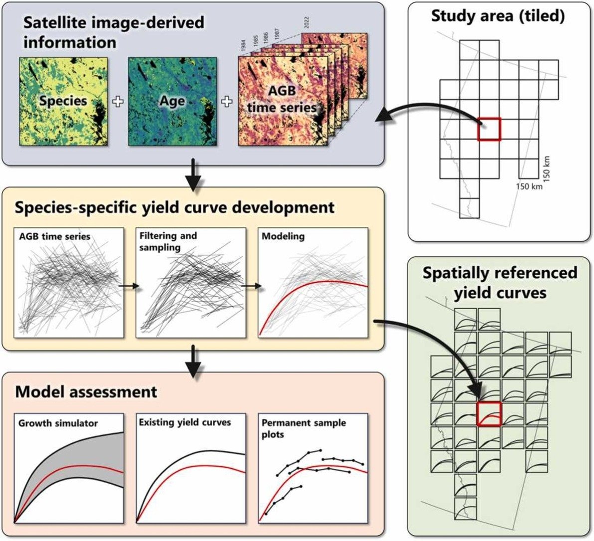
🆕.<a href="/PiotrTompalski/">Piotr Tompalski</a> et al. Developing aboveground biomass yield curves for dominant boreal tree species from time series remote sensing data. 📏⏱️🌲
➡️Models informed by annual biomass values, tree species, and age. 
#Landsat #carbon #NTEMS #OpenAccess
🔗sciencedirect.com/science/articl…
Dr. Jill Hamilton (@jilla_hamilton) 's Twitter Profile Photo

Our group is hiring a Research Technologist to contribute to lab and greenhouse activities for a diversity of tree genomics and conservation projects. Feel free to email to find out more! Great opportunity for BS or MSc! #ConservationGenetics psu.wd1.myworkdayjobs.com/en-US/PSU_Staf…

Integrated RS Studio (@irss_ubc) 's Twitter Profile Photo

NEW PAPER📢Using full potential of #AirborneLaserSanning (aerial #Lidar) in wildlife research 🔓#OpenAccess: doi.org/10.1002/wsb.15… in The Wildlife Society ✍️ Cosgrove (🌲Cameron Cosgrove🌲) Coops & Martin (Tara Martin) 🙏 NSERC / CRSNG @ubcforestry #RemoteSensing #WildlifeResearch

NEW PAPER📢Using full potential of #AirborneLaserSanning (aerial #Lidar) in wildlife research

🔓#OpenAccess: doi.org/10.1002/wsb.15… in <a href="/wildlifesociety/">The Wildlife Society</a>
✍️ Cosgrove (<a href="/CryptidCosgrove/">🌲Cameron Cosgrove🌲</a>) Coops &amp; Martin (<a href="/TaraGMartin/">Tara Martin</a>)
🙏 <a href="/NSERC_CRSNG/">NSERC / CRSNG</a>

@ubcforestry
#RemoteSensing #WildlifeResearch
Mike Wulder (@mikewulder) 's Twitter Profile Photo

Spatial resolution of source imagery has an impact on detail of mapped features. Big pixels are known to lead to an overestimation in #wildfire burned area estimates. We revisit the unprecedented 2023 fire season & investigate area burned, #landcover classes implicated, &

Spatial resolution of source imagery has an impact on detail of mapped features. Big pixels are known to lead to an overestimation in #wildfire burned area estimates. 
We revisit the unprecedented 2023 fire season &amp; investigate area burned, #landcover classes implicated, &amp;
Dr. Joanne C. White (@joanne_c_white) 's Twitter Profile Photo

What have been the contributions of #remotesensing to assessing post-disturbance #forestrecovery in #boreal #forests? What are future #research priorities? 👉Read my synthesis here: doi.org/10.14214/sf.23… #OpenAccess #Landsat #lidar

What have been the contributions of #remotesensing to assessing post-disturbance #forestrecovery in #boreal #forests? What are future #research priorities? 
👉Read my synthesis here: doi.org/10.14214/sf.23… 
#OpenAccess #Landsat #lidar
Txomin Hermosilla (@txominhermos) 's Twitter Profile Photo

Time series tree species maps for Canada’s forested ecosystems from 1984 to 2022 at 30 m spatial resolution using #Landsat imagery, topographic and climate data, and cal/val data from Canada’s NFI. 37 species, 39 years, 650 Mha! Paper: doi.org/10.1016/j.fore… #opendata & info⬇️📜

Integrated RS Studio (@irss_ubc) 's Twitter Profile Photo

NEW PAPER 📢 A #RemoteSensing methodology for sub-stand #GrowthAndYield projection of post-harvest #ForestRegeneration 🔓#OpenAccess: doi.org/10.1093/forest… ✍️ Chadwick, Coops, Johnson, Bater, Martens, Roeser, White 🙏 Alberta Forestry & Parks @ubcforestry #ForestInventory

NEW PAPER 📢

A #RemoteSensing methodology for sub-stand #GrowthAndYield projection of post-harvest #ForestRegeneration

🔓#OpenAccess: doi.org/10.1093/forest…
✍️ Chadwick, Coops, Johnson, Bater, Martens, Roeser, White
🙏 Alberta Forestry &amp; Parks 

@ubcforestry #ForestInventory
Txomin Hermosilla (@txominhermos) 's Twitter Profile Photo

Our multidecadal annual time series of dominant tree species layers for Canada are now available on the #GEE Community Catalog! 🛰️🌲🌳🗺️🇨🇦 Explore the data here:🔗gee-community-catalog.org/projects/ca_sp… Read more about our work: 📰doi.org/10.1016/j.fore…

Mike Wulder (@mikewulder) 's Twitter Profile Photo

Have multiple #landcover maps of same or overlapping area? We combine #forest & #agriculture sector #maps using error matrices & semantic affinity scores. Li et al. Land cover harmonization using Latent Dirichlet Allocation. #Landsat #landuse #Bayesian 🔗tandfonline.com/doi/full/10.10…