Storm_101
@tystorm101
Weather Enthusiast.
Trained Storm Spotter for NWS Louisville.
Makes Weather Predictions.
Photographs Weather in my Backyard.
Railfan.
Factory Worker at Hitachi.
ID: 506892477
http://www.youtube.com/channel/UCxcyGw_ZAhvYbdJBPJs8nUA 28-02-2012 04:38:58
15,15K Tweet
2,2K Followers
295 Following
 on Twitter photo RADAR @ 12:25PM EDT: Strong Storms are popping up generally along the I-75 Corridor moving ENE into Eastern KY. Some of these storms may contain up to 40mph wind gusts. #kywx")
 's Twitter Profile Photo")
 on Twitter photo 11:44am CDT #SPC_MD 1655 , #ohwx #kywx #inwx #ilwx #mowx, spc.noaa.gov/products/md/md…")
 's Twitter Profile Photo")
 on Twitter photo Severe Thunderstorm Warning including Jackson KY, Beattyville KY and Vancleve KY until 2:30 PM EDT")
 on Twitter photo Gotta watch Central KY for the Possibility of a couple of Microbursts. The Microburst Composite is pretty elevated. SBCAPE north of 4000J\Kg, MLCAPE up to 2500J/Kg, DCAPE 900-1300, and Steep Low-level Lapse Rates can favor some local Damaging Wind Bursts. #kywx")
 on Twitter photo The Cluster of Storms SW of Evansville IN is getting its act together a little bit and may run into the environment later this afternoon. Where its more right moving, it'll notably be stronger than some of the other storms. We'll see how this progresses. #kywx")
 on Twitter photo This cluster of storms will be capable of producing 30-50mph winds over the next couple hours across Southern IN and parts of KY. There is a dominant outflow boundary ahead of the storms which should fire more storms as it moves East. We had 60mph report from Princeton IN. #kywx")
 on Twitter photo Surprised that these Storms East of Lexington have no Special Weather Statements. These storms may be capable of 40-50mph Winds and Small Hail. #kywx")
 on Twitter photo A Cluster of Strong Storms is approaching Louisville. These storms can be capable of producing 30-50mph Winds. #kywx")
 's Twitter Profile Photo")
 on Twitter photo Severe Thunderstorm Warning including Cincinnati OH, Cincinnati-Northern Ky Airport KY and Covington KY until 7:15 PM EDT")
 on Twitter photo A Broken Band of Strong Storms is approaching the Lexington Area. Winds up to 40mph are likely in the strongest storms. #kywx")
 's Twitter Profile Photo")
 on Twitter photo Severe Thunderstorm Warning including Benton KY, Calvert City KY and Gilbertsville KY until 7:00 PM CDT")
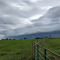
Stormy Skies at Brandon Crossing. #kywx Chris Bailey🌪️⚡️ Justin Logan FOX 56 Dillon Gaudet
 on Twitter photo Stormy Skies at Brandon Crossing. #kywx <a href=\"/Kentuckyweather/\">Chris Bailey🌪️⚡️</a> <a href=\"/jloganwxguy/\">Justin Logan FOX 56</a> <a href=\"/GaudetWeather/\">Dillon Gaudet</a>")
Beautiful Anvil Structure with Mammatus Clouds in Mercer County. #kywx Chris Bailey🌪️⚡️ Dillon Gaudet Justin Logan FOX 56
 on Twitter photo Beautiful Anvil Structure with Mammatus Clouds in Mercer County. #kywx <a href=\"/Kentuckyweather/\">Chris Bailey🌪️⚡️</a> <a href=\"/GaudetWeather/\">Dillon Gaudet</a> <a href=\"/jloganwxguy/\">Justin Logan FOX 56</a>")
 on Twitter photo Some Strong Storms will be possible again today especially for Western KY where we may have a MCV rolling through IL. There may be just enough Wind Shear for a Very Low Tornado Risk which is where the SPC has the 2% Tornado Risk though Strong Winds is the main threat. (1/2) #kywx")
 on Twitter photo 1:20pm CDT #SPC_MD 1660 , #inwx #kywx #ilwx #tnwx #mowx #arwx, spc.noaa.gov/products/md/md…")
 on Twitter photo Severe Thunderstorm Warning including Oak Grove KY, Pembroke KY and LaFayette KY until 5:00 PM CDT")
 's Twitter Profile Photo")
 on Twitter photo #WPC_MD 0675 affecting Portions of the OH Valley, #ohwx #kywx #inwx #ilwx, wpc.ncep.noaa.gov/metwatch/metwa…")
 on Twitter photo Cluster of Strong Storms capable of producing 40-50mph Winds approaching Russellville and perhaps making it to Bowling Green. #kywx")