Vector Charts (@vectorcharts) 's Twitter Profile
Vector Charts

@vectorcharts

the Nautical Chart API for web applications & maritime robotics. Add beautiful, informative vector nautical charts to your maritime product. by @chris_dalke

ID: 1915004834362650624

linkhttp://vectorcharts.com calendar_today23-04-2025 11:28:42

16 Tweet

159 Followers

9 Following

Vector Charts (@vectorcharts) 's Twitter Profile Photo

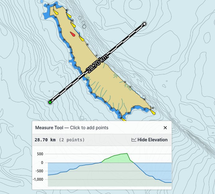
Easy access to nautical chart data unlocks hyper-relevant, hyper-local experiences — for example, this measurement tool which plots an elevation profile underneath a path

Easy access to nautical chart data unlocks hyper-relevant, hyper-local experiences — for example, this measurement tool which plots an elevation profile underneath a path
Vector Charts (@vectorcharts) 's Twitter Profile Photo

New API for our enterprise customers: Access the merged & post-processed ENC data as GeoJSON for path planning on your robot or other custom application.

Vector Charts (@vectorcharts) 's Twitter Profile Photo

Our vector tiles are supported by many modern map libraries including Mapbox GL JS, MapLibre, and OpenLayers. For older libraries that only support raster imagery, we also serve raster tiles. We're publishing examples for many libraries here: github.com/vector-charts/…

Vector Charts (@vectorcharts) 's Twitter Profile Photo

We just shipped a HUGE style update improving portrayal of navigational aids & lights, transit lanes, landmarks, and 100s of other layers. We're building the world's best nautical chart by thoughtfully combining the maps mariners understand with new tools for the modern web.

We just shipped a HUGE style update improving portrayal of navigational aids & lights, transit lanes, landmarks, and 100s of other layers.

We're building the world's best nautical chart by thoughtfully combining the maps mariners understand with new tools for the modern web.
Vector Charts (@vectorcharts) 's Twitter Profile Photo

Satellite imagery, 3D terrain, AND nautical charts? All possible when you combine modern web mapping libraries with our nautical chart tile API.

Vector Charts (@vectorcharts) 's Twitter Profile Photo

This week, we’re diving into how you can use our API with some common mapping libraries, GIS tools, and drone command & control software. Follow us to learn how you can add nautical charts to Mapbox GL JS, OpenLayers, QGroundControl, QGIS and more!

Vector Charts (@vectorcharts) 's Twitter Profile Photo

Next on our list of compatible libraries: MapLibre GL JS. Born as a fork of Mapbox, MapLibre has the same capability to render Vector Tiles with WebGL! youtu.be/3rvfKZ6n14E

Vector Charts (@vectorcharts) 's Twitter Profile Photo

Vector Charts isn’t just for integration into new products. You can also drop it directly into tools you already use! For example, here’s how you can add our charts as a background layer in #QGroundControl, for use mission planning with #ardupilot USVs: youtu.be/g7G6jCj2R4I?si…